Jalai Nur geodata
Jalai Nur (Inner Mongolia) is a seat of a fourth-order administrative division; located in China in Asia/Shanghai (GMT+8) time zone. With population of 107,828 people, there are 408 cities with bigger population in this country. Compared to other cities in China, 99.4% of cities are located further ↓South; 69.5% of cities are located further ←West and 76.7% of cities have lower elevation than Jalai Nur. Note1


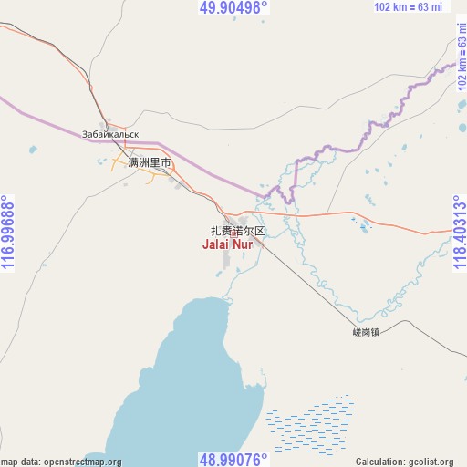
Jalai Nur GPS coordinates[2]
49° 27' 0" North, 117° 42' 0" East
| Map corner | latitude | longitude |
|---|---|---|
| Upper-left | 49.90498°, | 116.99688° |
| Center: | 49.45°, | 117.7° |
| Lower-right: | 48.99076°, | 118.40313° |
| Map W x H: | 101.7×101.7 km | = 63.2×63.2mi |
| max Lat: | 53.31946° ⇑0.6% North |
| Jalai Nur: | 49.45° |
| min Lat: | ⇓99.4% South 18.22056° |
| min Long | Jalai Nur | max Long |
| 75.07348° | 117.7° | 134.28917° |
| W 69.5%⇐ | ⇒30.5% E |
Elevation
Elevation of Jalai Nur is 566 m = 1857 ft, and this is 81.2 m = 266 ft above average elevation for this country.
| Max E: |
5622 m = 18445 ft | 23.3% |
| Jalai Nur | 566 m 1857 ft | |
| Avg. | 484.8 m = 1591 ft | |
Min E: |
-3 m = -10 ft | 76.7% |
See also: Jalai Nur elevation on elevation.city.
Geographical zone
Jalai Nur is located in North temperate zone (between Tropic of Cancer and the Arctic Circle). Distance of this North polar circle is 1902.8 km =1182.3 mi to North.| Distance of | km | miles | from Jalai Nur |
|---|---|---|---|
| North Pole | 4508.7 | 2801.6 | to North |
| Arctic Circle | 1902.8 | 1182.3 | to North |
| Tropic Cancer | 2892.4 | 1797.3 | to South |
| Equator | 5498.3 | 3416.5 | to South |


Nearby cities:
15 places around Jalai Nur: (largest is in red/bold)
• Alatan'molezhen
108.7 km =67.5 mi,  216°
216°
• Amgalang
138.4 km =86 mi,  164°
164°
• Amu Gulang Baolige
125.5 km =78 mi,  165°
165°
• A’ershan
100.5 km =62.4 mi,  214°
214°
• Baogede Wula
115.3 km =71.6 mi,  196°
196°
• Bayan Hure
131.4 km =81.6 mi,  87°
87°
• Cuogang
36.1 km =22.4 mi,  126°
126°
• Dalai
63.9 km =39.7 mi,  235°
235°
• Dalaidong
43.4 km =27 mi,  259°
259°
• E’erdun Wula
89.4 km =55.6 mi,  229°
229°
• Hulun
104.7 km =65.1 mi, 211°
• Jibu Hulangtu
54 km =33.6 mi,  175°
175°
• Manzhouli
25.5 km =15.8 mi,  310°
310°
• Wangong
91 km =56.5 mi,  108°
108°
• Xinbaoli Gedong
112.9 km =70.2 mi,  135°
135°
Sources, notices
• [Note1] Compared only with cities in China existing in our database
• [Src1] Map data: © OpenStreetMap contributors (CC-BY-SA)
• [Src2] Other city data from geonames.org with taken over terms of usage.
• [Src3] Geographical zone / Annual Mean Temperature by Robert A. Rohde @ Wikipedia
