Manzhouli geodata
Manzhouli (Inner Mongolia) is a populated place; located in China in Asia/Shanghai (GMT+8) time zone. With population of 54,808 people, there are 794 cities with bigger population in this country. Compared to other cities in China, 99.5% of cities are located further ↓South; 68.4% of cities are located further ←West and 79% of cities have lower elevation than Manzhouli. Note1


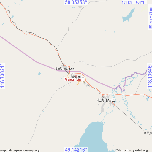
Manzhouli GPS coordinates[2]
49° 36' 0" North, 117° 25' 59.988" East
| Map corner | latitude | longitude |
|---|---|---|
| Upper-left | 50.05358°, | 116.73021° |
| Center: | 49.6°, | 117.43333° |
| Lower-right: | 49.14216°, | 118.13646° |
| Map W x H: | 101.3×101.3 km | = 62.9×62.9mi |
| max Lat: | 53.31946° ⇑0.5% North |
| Manzhouli: | 49.6° |
| min Lat: | ⇓99.5% South 18.22056° |
| min Long | Manzhouli | max Long |
| 75.07348° | 117.43333° | 134.28917° |
| W 68.4%⇐ | ⇒31.6% E |
Elevation
Elevation of Manzhouli is 651 m = 2136 ft, and this is 166.2 m = 545 ft above average elevation for this country.
| Max E: |
5622 m = 18445 ft | 21% |
| Manzhouli | 651 m 2136 ft | |
| Avg. | 484.8 m = 1591 ft | |
Min E: |
-3 m = -10 ft | 79% |
See also: Manzhouli elevation on elevation.city.
Geographical zone
Manzhouli is located in North temperate zone (between Tropic of Cancer and the Arctic Circle). Distance of this North polar circle is 1886.2 km =1172 mi to North.| Distance of | km | miles | from Manzhouli |
|---|---|---|---|
| North Pole | 4492.1 | 2791.3 | to North |
| Arctic Circle | 1886.2 | 1172 | to North |
| Tropic Cancer | 2909.1 | 1807.6 | to South |
| Equator | 5515 | 3426.9 | to South |


Nearby cities:
15 places around Manzhouli: (largest is in red/bold)
• Alatan'molezhen
113.5 km =70.5 mi,  203°
203°
• Amu Gulang Baolige
147.4 km =91.6 mi,  159°
159°
• A’ershan
106.5 km =66.2 mi, 200°
• Baogede Wula
127.9 km =79.5 mi,  186°
186°
• Bayan Hure
150.7 km =93.6 mi,  94°
94°
• Cuogang
61.5 km =38.2 mi,  128°
128°
• Dalai
62.4 km =38.8 mi,  212°
212°
• Dalaidong
33.8 km =21 mi,  223°
223°
• E’erdun Wula
89.2 km =55.4 mi, 212°
• Hangwula
144.4 km =89.7 mi, 209°
• Hulun
111.5 km =69.3 mi, 198°
• Jalai Nur
25.5 km =15.8 mi, 130°
• Jibu Hulangtu
74.4 km =46.2 mi, 161°
• Wangong
114.9 km =71.4 mi,  113°
113°
• Xinbaoli Gedong
138.3 km =85.9 mi, 134°
Sources, notices
• [Note1] Compared only with cities in China existing in our database
• [Src1] Map data: © OpenStreetMap contributors (CC-BY-SA)
• [Src2] Other city data from geonames.org with taken over terms of usage.
• [Src3] Geographical zone / Annual Mean Temperature by Robert A. Rohde @ Wikipedia
