Hohhot geodata
Hohhot (Inner Mongolia) is a seat of a first-order administrative division; located in China in Asia/Shanghai (GMT+8) time zone. With population of 774,477 people, there are 77 cities with bigger population in this country. Compared to other cities in China, 88.8% of cities are located further ↓South; 64.2% of cities are located further →East and 86.1% of cities have lower elevation than Hohhot. Note1


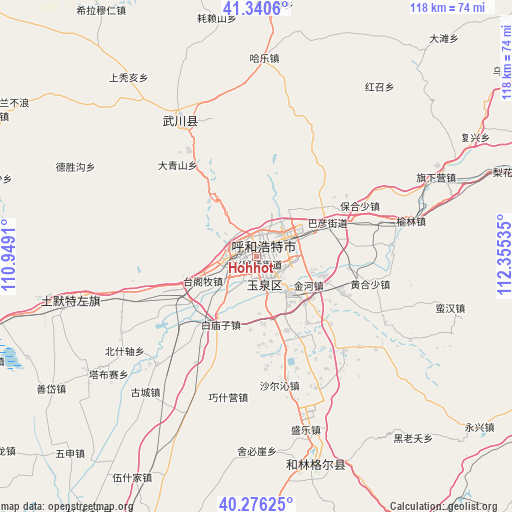
Hohhot GPS coordinates[2]
40° 48' 38.016" North, 111° 39' 7.992" East
| Map corner | latitude | longitude |
|---|---|---|
| Upper-left | 41.3406°, | 110.9491° |
| Center: | 40.81056°, | 111.65222° |
| Lower-right: | 40.27625°, | 112.35535° |
| Map W x H: | 118.3×118.3 km | = 73.5×73.5mi |
| max Lat: | 53.31946° ⇑11.2% North |
| Hohhot: | 40.81056° |
| min Lat: | ⇓88.8% South 18.22056° |
| min Long | Hohhot | max Long |
| 75.07348° | 111.65222° | 134.28917° |
| W 35.8%⇐ | ⇒64.2% E |
Elevation
Elevation of Hohhot is 1051 m = 3448 ft, and this is 566.2 m = 1858 ft above average elevation for this country.
| Max E: |
5622 m = 18445 ft | 13.9% |
| Hohhot | 1051 m 3448 ft | |
| Avg. | 484.8 m = 1591 ft | |
Min E: |
-3 m = -10 ft | 86.1% |
See also: Hohhot elevation on elevation.city.
Geographical zone
Hohhot is located in North temperate zone (between Tropic of Cancer and the Arctic Circle). Distance of this Northern Tropic circle is 1931.8 km =1200.4 mi to South.| Distance of | km | miles | from Hohhot |
|---|---|---|---|
| North Pole | 5469.4 | 3398.5 | to North |
| Arctic Circle | 2863.5 | 1779.3 | to North |
| Tropic Cancer | 1931.8 | 1200.4 | to South |
| Equator | 4537.7 | 2819.6 | to South |


Nearby cities:
15 places around Hohhot: (largest is in red/bold)
• Anzihao
38.8 km =24.1 mi,  331°
331°
• Changhan Mutai
56.6 km =35.2 mi, 332°
• Dadoupu
39.4 km =24.5 mi,  353°
353°
• Dalanqi
38.2 km =23.7 mi,  11°
11°
• Daqingshan
27.4 km =17 mi,  320°
320°
• Dongtucheng
47.5 km =29.5 mi, 316°
• Hale
45.4 km =28.2 mi,  2°
2°
• Haolaishan
56 km =34.8 mi, 350°
• Haoxinying
9.6 km =6 mi,  33°
33°
• Hoh Ereg
36.3 km =22.6 mi, 330°
• Menggusi
59.9 km =37.2 mi, 30°
• Moguyao
42 km =26.1 mi,  299°
299°
• Nalinggou
46.2 km =28.7 mi, 296°
• Qasq
45.4 km =28.2 mi,  256°
256°
• Shangtuhai
50.2 km =31.2 mi, 325°
Sources, notices
• [Note1] Compared only with cities in China existing in our database
• [Src1] Map data: © OpenStreetMap contributors (CC-BY-SA)
• [Src2] Other city data from geonames.org with taken over terms of usage.
• [Src3] Geographical zone / Annual Mean Temperature by Robert A. Rohde @ Wikipedia
