Shangtuhai geodata
Shangtuhai (Inner Mongolia) is a seat of a fourth-order administrative division; located in China in Asia/Shanghai (GMT+8) time zone. In our database, there are 1268 cities with bigger population. Compared to other cities in China, 89.5% of cities are located further ↓South; 65.9% of cities are located further →East and 92.2% of cities have lower elevation than Shangtuhai. Note1


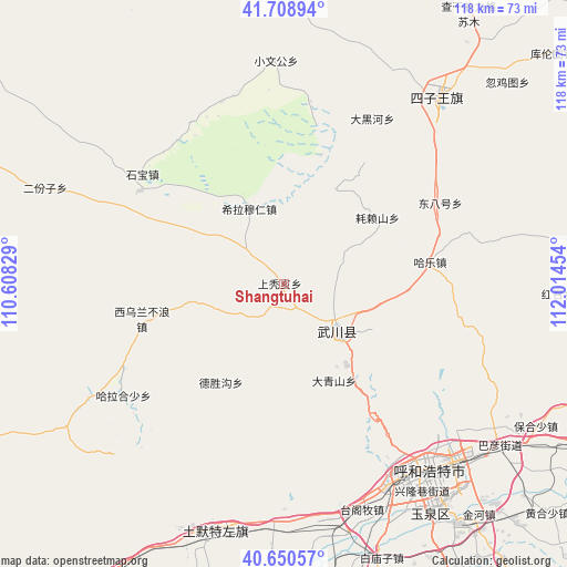
Shangtuhai GPS coordinates[2]
41° 10' 54.804" North, 111° 18' 41.076" East
| Map corner | latitude | longitude |
|---|---|---|
| Upper-left | 41.70894°, | 110.60829° |
| Center: | 41.18189°, | 111.31141° |
| Lower-right: | 40.65057°, | 112.01454° |
| Map W x H: | 117.7×117.7 km | = 73.1×73.1mi |
| max Lat: | 53.31946° ⇑10.5% North |
| Shangtuhai: | 41.18189° |
| min Lat: | ⇓89.5% South 18.22056° |
| min Long | Shangtuhai | max Long |
| 75.07348° | 111.31141° | 134.28917° |
| W 34.1%⇐ | ⇒65.9% E |
Elevation
Elevation of Shangtuhai is 1604 m = 5262 ft, and this is 1119.2 m = 3672 ft above average elevation for this country.
| Max E: |
5622 m = 18445 ft | 7.8% |
| Shangtuhai | 1604 m 5262 ft | |
| Avg. | 484.8 m = 1591 ft | |
Min E: |
-3 m = -10 ft | 92.2% |
See also: China elevation on elevation.city.
Geographical zone
Shangtuhai is located in North temperate zone (between Tropic of Cancer and the Arctic Circle). Distance of this Northern Tropic circle is 1973.1 km =1226 mi to South.| Distance of | km | miles | from Shangtuhai |
|---|---|---|---|
| North Pole | 5428.1 | 3372.9 | to North |
| Arctic Circle | 2822.2 | 1753.6 | to North |
| Tropic Cancer | 1973.1 | 1226 | to South |
| Equator | 4579 | 2845.3 | to South |


Nearby cities:
15 places around Shangtuhai: (largest is in red/bold)
• Anzihao
12.5 km =7.8 mi,  124°
124°
• Changhan Mutai
9.1 km =5.7 mi,  14°
14°
• Dadoupu
24.3 km =15.1 mi,  95°
95°
• Dalanqi
36.6 km =22.7 mi, 96°
• Daqingshan
23.1 km =14.4 mi,  151°
151°
• Donghongsheng
39.5 km =24.5 mi,  295°
295°
• Dongtucheng
8.2 km =5.1 mi,  211°
211°
• Hale
30.7 km =19.1 mi,  82°
82°
• Haolaishan
24 km =14.9 mi,  54°
54°
• Har Huxu
40.2 km =25 mi,  234°
234°
• Hoh Ereg
14.5 km =9 mi,  131°
131°
• Moguyao
22 km =13.7 mi,  200°
200°
• Nalinggou
23.9 km =14.9 mi, 211°
• Xiwulan Bulang
29.5 km =18.3 mi,  256°
256°
• Zhonghouhe
20.5 km =12.7 mi,  271°
271°
Sources, notices
• [Note1] Compared only with cities in China existing in our database
• [Src1] Map data: © OpenStreetMap contributors (CC-BY-SA)
• [Src2] Other city data from geonames.org with taken over terms of usage.
• [Src3] Geographical zone / Annual Mean Temperature by Robert A. Rohde @ Wikipedia
