Changhan Mutai geodata
Changhan Mutai (Inner Mongolia) is a seat of a fourth-order administrative division; located in China in Asia/Shanghai (GMT+8) time zone. In our database, there are 1268 cities with bigger population. Compared to other cities in China, 89.7% of cities are located further ↓South; 65.7% of cities are located further →East and 92.2% of cities have lower elevation than Changhan Mutai. Note1


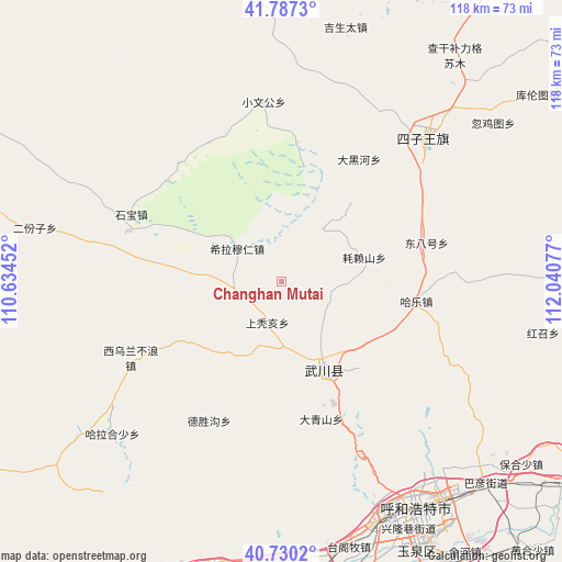
Changhan Mutai GPS coordinates[2]
41° 15' 39.204" North, 111° 20' 15.504" East
| Map corner | latitude | longitude |
|---|---|---|
| Upper-left | 41.7873°, | 110.63452° |
| Center: | 41.26089°, | 111.33764° |
| Lower-right: | 40.7302°, | 112.04077° |
| Map W x H: | 117.5×117.5 km | = 73×73mi |
| max Lat: | 53.31946° ⇑10.3% North |
| Changhan Mutai: | 41.26089° |
| min Lat: | ⇓89.7% South 18.22056° |
| min Long | Changhan Mutai | max Long |
| 75.07348° | 111.33764° | 134.28917° |
| W 34.3%⇐ | ⇒65.7% E |
Elevation
Elevation of Changhan Mutai is 1606 m = 5269 ft, and this is 1121.2 m = 3678 ft above average elevation for this country.
| Max E: |
5622 m = 18445 ft | 7.8% |
| Changhan Mutai | 1606 m 5269 ft | |
| Avg. | 484.8 m = 1591 ft | |
Min E: |
-3 m = -10 ft | 92.2% |
See also: China elevation on elevation.city.
Geographical zone
Changhan Mutai is located in North temperate zone (between Tropic of Cancer and the Arctic Circle). Distance of this Northern Tropic circle is 1981.9 km =1231.5 mi to South.| Distance of | km | miles | from Changhan Mutai |
|---|---|---|---|
| North Pole | 5419.3 | 3367.4 | to North |
| Arctic Circle | 2813.4 | 1748.2 | to North |
| Tropic Cancer | 1981.9 | 1231.5 | to South |
| Equator | 4587.8 | 2850.7 | to South |


Nearby cities:
15 places around Changhan Mutai: (largest is in red/bold)
• Anzihao
17.8 km =11.1 mi,  152°
152°
• Dadoupu
24.5 km =15.2 mi,  116°
116°
• Dalanqi
36.4 km =22.6 mi,  110°
110°
• Daqingshan
30.4 km =18.9 mi,  162°
162°
• Donghongsheng
38.7 km =24 mi,  281°
281°
• Dongtucheng
17.1 km =10.6 mi,  202°
202°
• Hale
28.6 km =17.8 mi,  99°
99°
• Haolaishan
18.1 km =11.2 mi,  73°
73°
• Hoh Ereg
20.3 km =12.6 mi, 154°
• Moguyao
31 km =19.3 mi, 198°
• Nalinggou
32.7 km =20.3 mi,  206°
206°
• Shangtuhai
9.1 km =5.7 mi,  194°
194°
• Ulan Hua
41 km =25.5 mi,  46°
46°
• Xiwulan Bulang
34.6 km =21.5 mi,  242°
242°
• Zhonghouhe
24.2 km =15 mi,  249°
249°
Sources, notices
• [Note1] Compared only with cities in China existing in our database
• [Src1] Map data: © OpenStreetMap contributors (CC-BY-SA)
• [Src2] Other city data from geonames.org with taken over terms of usage.
• [Src3] Geographical zone / Annual Mean Temperature by Robert A. Rohde @ Wikipedia
