Fengshan geodata
Fengshan (Heilongjiang) is a seat of a fourth-order administrative division; located in China in Asia/Shanghai (GMT+8) time zone. In our database, there are 1268 cities with bigger population. Compared to other cities in China, 95.5% of cities are located further ↓South; 98.2% of cities are located further ←West and 50.5% of cities have higher elevation than Fengshan. Note1


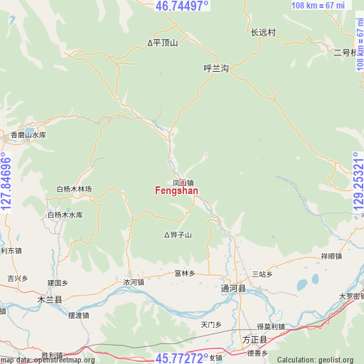
Fengshan GPS coordinates[2]
46° 15' 39.6" North, 128° 33' 0.288" East
| Map corner | latitude | longitude |
|---|---|---|
| Upper-left | 46.74497°, | 127.84696° |
| Center: | 46.261°, | 128.55008° |
| Lower-right: | 45.77272°, | 129.25321° |
| Map W x H: | 108.1×108.1 km | = 67.2×67.2mi |
| max Lat: | 53.31946° ⇑4.5% North |
| Fengshan: | 46.261° |
| min Lat: | ⇓95.5% South 18.22056° |
| min Long | Fengshan | max Long |
| 75.07348° | 128.55008° | 134.28917° |
| W 98.2%⇐ | ⇒1.8% E |
Elevation
Elevation of Fengshan is 160 m = 525 ft, and this is 324.8 m = 1066 ft below average elevation for this country.
| Max E: |
5622 m = 18445 ft | 50.5% |
| Avg. | 484.8 m = 1591 ft | |
| Fengshan | 160 m = 525 ft | |
Min E: |
-3 m = -10 ft | 49.5% |
See also: China elevation on elevation.city.
Geographical zone
Fengshan is located in North temperate zone (between Tropic of Cancer and the Arctic Circle). Distance of this North polar circle is 2257.4 km =1402.7 mi to North.| Distance of | km | miles | from Fengshan |
|---|---|---|---|
| North Pole | 4863.3 | 3021.9 | to North |
| Arctic Circle | 2257.4 | 1402.7 | to North |
| Tropic Cancer | 2537.8 | 1576.9 | to South |
| Equator | 5143.7 | 3196.1 | to South |


Nearby cities:
15 places around Fengshan: (largest is in red/bold)
• Dongxing
54.3 km =33.7 mi,  284°
284°
• Fangzheng
51.6 km =32.1 mi,  155°
155°
• Huifa
52.9 km =32.9 mi,  170°
170°
• Jianguo
47.7 km =29.6 mi,  231°
231°
• Jixing
56.8 km =35.3 mi,  240°
240°
• Lidong
54.6 km =33.9 mi,  248°
248°
• Mulan
52.7 km =32.7 mi, 228°
• Nonghe
33 km =20.5 mi,  206°
206°
• Songnan
46.9 km =29.1 mi, 155°
• Tianmen
43.1 km =26.8 mi, 168°
• Tonghe
35 km =21.7 mi,  154°
154°
• Wuyapao
39.1 km =24.3 mi,  144°
144°
• Xiangshun
49.3 km =30.6 mi,  116°
116°
• Xinmin
56.8 km =35.3 mi, 276°
• Yihantong
50.4 km =31.3 mi, 148°
Sources, notices
• [Note1] Compared only with cities in China existing in our database
• [Src1] Map data: © OpenStreetMap contributors (CC-BY-SA)
• [Src2] Other city data from geonames.org with taken over terms of usage.
• [Src3] Geographical zone / Annual Mean Temperature by Robert A. Rohde @ Wikipedia
