Dongxing geodata
Dongxing (Heilongjiang) is a seat of a fourth-order administrative division; located in China in Asia/Shanghai (GMT+8) time zone. In our database, there are 1268 cities with bigger population. Compared to other cities in China, 95.7% of cities are located further ↓South; 97.9% of cities are located further ←West and 50.5% of cities have higher elevation than Dongxing. Note1


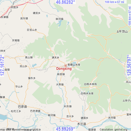
Dongxing GPS coordinates[2]
46° 22' 47.676" North, 127° 51' 53.424" East
| Map corner | latitude | longitude |
|---|---|---|
| Upper-left | 46.86282°, | 127.16172° |
| Center: | 46.37991°, | 127.86484° |
| Lower-right: | 45.89269°, | 128.56797° |
| Map W x H: | 107.9×107.9 km | = 67×67mi |
| max Lat: | 53.31946° ⇑4.3% North |
| Dongxing: | 46.37991° |
| min Lat: | ⇓95.7% South 18.22056° |
| min Long | Dongxing | max Long |
| 75.07348° | 127.86484° | 134.28917° |
| W 97.9%⇐ | ⇒2.1% E |
Elevation
Elevation of Dongxing is 160 m = 525 ft, and this is 324.8 m = 1066 ft below average elevation for this country.
| Max E: |
5622 m = 18445 ft | 50.5% |
| Avg. | 484.8 m = 1591 ft | |
| Dongxing | 160 m = 525 ft | |
Min E: |
-3 m = -10 ft | 49.5% |
See also: China elevation on elevation.city.
Geographical zone
Dongxing is located in North temperate zone (between Tropic of Cancer and the Arctic Circle). Distance of this North polar circle is 2244.2 km =1394.5 mi to North.| Distance of | km | miles | from Dongxing |
|---|---|---|---|
| North Pole | 4850.1 | 3013.7 | to North |
| Arctic Circle | 2244.2 | 1394.5 | to North |
| Tropic Cancer | 2551 | 1585.1 | to South |
| Equator | 5157 | 3204.4 | to South |


Nearby cities:
15 places around Dongxing: (largest is in red/bold)
• Bayangang
45 km =28 mi,  213°
213°
• Dagui
16 km =9.9 mi,  196°
196°
• Daluo
35.1 km =21.8 mi,  320°
320°
• Heishan
31.1 km =19.3 mi,  282°
282°
• Huashan
41.9 km =26 mi,  246°
246°
• Jixing
41.7 km =25.9 mi,  175°
175°
• Jubaoshan
40.4 km =25.1 mi, 317°
• Lidong
33.5 km =20.8 mi, 176°
• Liuhe
42.5 km =26.4 mi, 195°
• Longquan
36.7 km =22.8 mi,  238°
238°
• Shanhou
42.5 km =26.4 mi,  303°
303°
• Waxing
29.7 km =18.5 mi,  265°
265°
• Xinmin
7.7 km =4.8 mi, 208°
• Xinsheng
43.9 km =27.3 mi,  343°
343°
• Zhendong
29.4 km =18.3 mi, 250°
Sources, notices
• [Note1] Compared only with cities in China existing in our database
• [Src1] Map data: © OpenStreetMap contributors (CC-BY-SA)
• [Src2] Other city data from geonames.org with taken over terms of usage.
• [Src3] Geographical zone / Annual Mean Temperature by Robert A. Rohde @ Wikipedia
