Waxing geodata
Waxing (Heilongjiang) is a seat of a fourth-order administrative division; located in China in Asia/Shanghai (GMT+8) time zone. In our database, there are 1268 cities with bigger population. Compared to other cities in China, 95.7% of cities are located further ↓South; 97.5% of cities are located further ←West and 52.1% of cities have higher elevation than Waxing. Note1


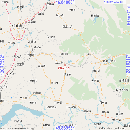
Waxing GPS coordinates[2]
46° 21' 25.056" North, 127° 28' 44.544" East
| Map corner | latitude | longitude |
|---|---|---|
| Upper-left | 46.84008°, | 126.77592° |
| Center: | 46.35696°, | 127.47904° |
| Lower-right: | 45.86953°, | 128.18217° |
| Map W x H: | 107.9×107.9 km | = 67×67mi |
| max Lat: | 53.31946° ⇑4.3% North |
| Waxing: | 46.35696° |
| min Lat: | ⇓95.7% South 18.22056° |
| min Long | Waxing | max Long |
| 75.07348° | 127.47904° | 134.28917° |
| W 97.5%⇐ | ⇒2.5% E |
Elevation
Elevation of Waxing is 149 m = 489 ft, and this is 335.8 m = 1102 ft below average elevation for this country.
| Max E: |
5622 m = 18445 ft | 52.1% |
| Avg. | 484.8 m = 1591 ft | |
| Waxing | 149 m = 489 ft | |
Min E: |
-3 m = -10 ft | 47.9% |
See also: China elevation on elevation.city.
Geographical zone
Waxing is located in North temperate zone (between Tropic of Cancer and the Arctic Circle). Distance of this North polar circle is 2246.8 km =1396.1 mi to North.| Distance of | km | miles | from Waxing |
|---|---|---|---|
| North Pole | 4852.7 | 3015.3 | to North |
| Arctic Circle | 2246.8 | 1396.1 | to North |
| Tropic Cancer | 2548.5 | 1583.6 | to South |
| Equator | 5154.4 | 3202.8 | to South |


Nearby cities:
15 places around Waxing: (largest is in red/bold)
• Bayan
31.9 km =19.8 mi,  191°
191°
• Dagui
28.2 km =17.5 mi,  116°
116°
• Daluo
30.4 km =18.9 mi,  13°
13°
• Dexiang
27.1 km =16.8 mi,  303°
303°
• Dongxing
29.7 km =18.5 mi,  85°
85°
• Fengle
29.2 km =18.1 mi,  243°
243°
• Heishan
9.6 km =6 mi,  355°
355°
• Huashan
16.9 km =10.5 mi,  211°
211°
• Jubaoshan
32.3 km =20.1 mi,  3°
3°
• Longmiao
19.3 km =12 mi,  268°
268°
• Longquan
16.7 km =10.4 mi, 185°
• Shanhou
26.6 km =16.5 mi,  347°
347°
• Xinglong
30.5 km =19 mi,  287°
287°
• Xinmin
26.2 km =16.3 mi,  99°
99°
• Zhendong
7.7 km =4.8 mi,  165°
165°
Sources, notices
• [Note1] Compared only with cities in China existing in our database
• [Src1] Map data: © OpenStreetMap contributors (CC-BY-SA)
• [Src2] Other city data from geonames.org with taken over terms of usage.
• [Src3] Geographical zone / Annual Mean Temperature by Robert A. Rohde @ Wikipedia
