Dazhuangke geodata
Dazhuangke (Beijing) is a seat of a fourth-order administrative division; located in China in Asia/Shanghai (GMT+8) time zone. In our database, there are 1268 cities with bigger population. Compared to other cities in China, 87.9% of cities are located further ↓South; 61.3% of cities are located further ←West and 74.1% of cities have lower elevation than Dazhuangke. Note1


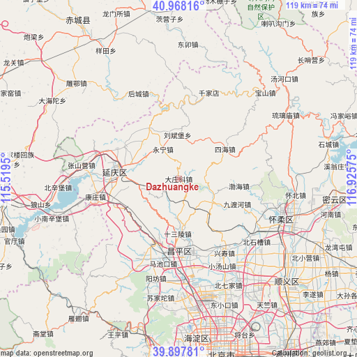
Dazhuangke GPS coordinates[2]
40° 26' 6.396" North, 116° 13' 21.432" East
| Map corner | latitude | longitude |
|---|---|---|
| Upper-left | 40.96816°, | 115.5195° |
| Center: | 40.43511°, | 116.22262° |
| Lower-right: | 39.89781°, | 116.92575° |
| Map W x H: | 119×119 km | = 73.9×73.9mi |
| max Lat: | 53.31946° ⇑12.1% North |
| Dazhuangke: | 40.43511° |
| min Lat: | ⇓87.9% South 18.22056° |
| min Long | Dazhuangke | max Long |
| 75.07348° | 116.22262° | 134.28917° |
| W 61.3%⇐ | ⇒38.7% E |
Elevation
Elevation of Dazhuangke is 504 m = 1654 ft, and this is 19.2 m = 63 ft above average elevation for this country.
| Max E: |
5622 m = 18445 ft | 25.9% |
| Dazhuangke | 504 m 1654 ft | |
| Avg. | 484.8 m = 1591 ft | |
Min E: |
-3 m = -10 ft | 74.1% |
See also: China elevation on elevation.city.
Geographical zone
Dazhuangke is located in North temperate zone (between Tropic of Cancer and the Arctic Circle). Distance of this Northern Tropic circle is 1890 km =1174.4 mi to South.| Distance of | km | miles | from Dazhuangke |
|---|---|---|---|
| North Pole | 5511.1 | 3424.4 | to North |
| Arctic Circle | 2905.2 | 1805.2 | to North |
| Tropic Cancer | 1890 | 1174.4 | to South |
| Equator | 4496 | 2793.7 | to South |


Nearby cities:
15 places around Dazhuangke: (largest is in red/bold)
• Badaling
21.6 km =13.4 mi,  248°
248°
• Bohai
21 km =13 mi,  97°
97°
• Changling
15.7 km =9.8 mi,  172°
172°
• Dayushu
17 km =10.6 mi,  269°
269°
• Jingzhuang
11.5 km =7.1 mi,  285°
285°
• Jiuduhe
21.8 km =13.5 mi,  112°
112°
• Jiuxian
17.1 km =10.6 mi,  318°
318°
• Liubinbu
14.7 km =9.1 mi,  356°
356°
• Shenjiaying
16.2 km =10.1 mi, 290°
• Shisanling
18.3 km =11.4 mi,  179°
179°
• Sihai
18.4 km =11.4 mi,  57°
57°
• Xiangying
16.1 km =10 mi,  336°
336°
• Yanqing
21.4 km =13.3 mi,  277°
277°
• Yongning
11.4 km =7.1 mi,  331°
331°
• Zhenzhuquan
21.3 km =13.2 mi,  50°
50°
Sources, notices
• [Note1] Compared only with cities in China existing in our database
• [Src1] Map data: © OpenStreetMap contributors (CC-BY-SA)
• [Src2] Other city data from geonames.org with taken over terms of usage.
• [Src3] Geographical zone / Annual Mean Temperature by Robert A. Rohde @ Wikipedia
