Jingzhuang geodata
Jingzhuang (Beijing) is a seat of a fourth-order administrative division; located in China in Asia/Shanghai (GMT+8) time zone. In our database, there are 1268 cities with bigger population. Compared to other cities in China, 88% of cities are located further ↓South; 60.5% of cities are located further ←West and 75.2% of cities have lower elevation than Jingzhuang. Note1


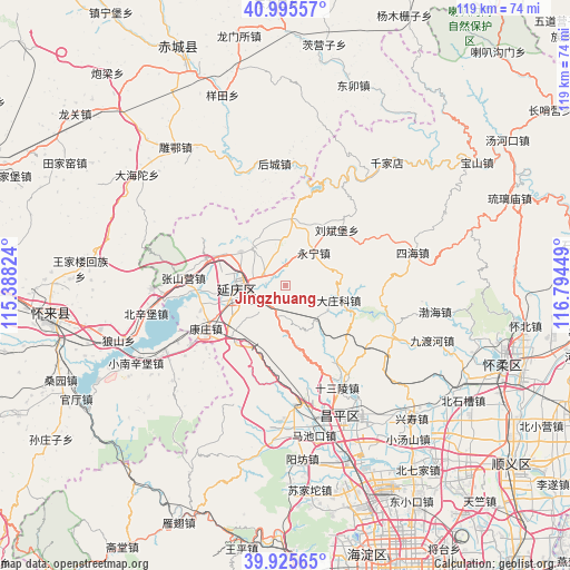
Jingzhuang GPS coordinates[2]
40° 27' 45.864" North, 116° 5' 28.896" East
| Map corner | latitude | longitude |
|---|---|---|
| Upper-left | 40.99557°, | 115.38824° |
| Center: | 40.46274°, | 116.09136° |
| Lower-right: | 39.92565°, | 116.79449° |
| Map W x H: | 119×119 km | = 73.9×73.9mi |
| max Lat: | 53.31946° ⇑12% North |
| Jingzhuang: | 40.46274° |
| min Lat: | ⇓88% South 18.22056° |
| min Long | Jingzhuang | max Long |
| 75.07348° | 116.09136° | 134.28917° |
| W 60.5%⇐ | ⇒39.5% E |
Elevation
Elevation of Jingzhuang is 527 m = 1729 ft, and this is 42.2 m = 138 ft above average elevation for this country.
| Max E: |
5622 m = 18445 ft | 24.8% |
| Jingzhuang | 527 m 1729 ft | |
| Avg. | 484.8 m = 1591 ft | |
Min E: |
-3 m = -10 ft | 75.2% |
See also: China elevation on elevation.city.
Geographical zone
Jingzhuang is located in North temperate zone (between Tropic of Cancer and the Arctic Circle). Distance of this Northern Tropic circle is 1893.1 km =1176.3 mi to South.| Distance of | km | miles | from Jingzhuang |
|---|---|---|---|
| North Pole | 5508 | 3422.5 | to North |
| Arctic Circle | 2902.1 | 1803.3 | to North |
| Tropic Cancer | 1893.1 | 1176.3 | to South |
| Equator | 4499 | 2795.5 | to South |


Nearby cities:
15 places around Jingzhuang: (largest is in red/bold)
• Badaling
14.2 km =8.8 mi,  219°
219°
• Changling
22.9 km =14.2 mi,  144°
144°
• Dayushu
6.8 km =4.2 mi,  240°
240°
• Dazhuangke
11.5 km =7.1 mi,  105°
105°
• Jiuxian
9.8 km =6.1 mi,  358°
358°
• Kangzhuang
19.2 km =11.9 mi, 240°
• Liubinbu
15.5 km =9.6 mi,  41°
41°
• Nankou
25.4 km =15.8 mi,  173°
173°
• Shenjiaying
4.8 km =3 mi,  302°
302°
• Shisanling
24.2 km =15 mi,  152°
152°
• Sihai
27.4 km =17 mi,  75°
75°
• Xiangying
12.6 km =7.8 mi,  21°
21°
• Yanqing
10.1 km =6.3 mi,  268°
268°
• Yongning
8.9 km =5.5 mi, 38°
• Zhenzhuquan
29.4 km =18.3 mi,  69°
69°
Sources, notices
• [Note1] Compared only with cities in China existing in our database
• [Src1] Map data: © OpenStreetMap contributors (CC-BY-SA)
• [Src2] Other city data from geonames.org with taken over terms of usage.
• [Src3] Geographical zone / Annual Mean Temperature by Robert A. Rohde @ Wikipedia
