Linghai geodata
Linghai (Liaoning) is a populated place; located in China in Asia/Shanghai (GMT+8) time zone. With population of 56,176 people, there are 780 cities with bigger population in this country. Compared to other cities in China, 89.5% of cities are located further ↓South; 89.4% of cities are located further ←West and 79.8% of cities have higher elevation than Linghai. Note1


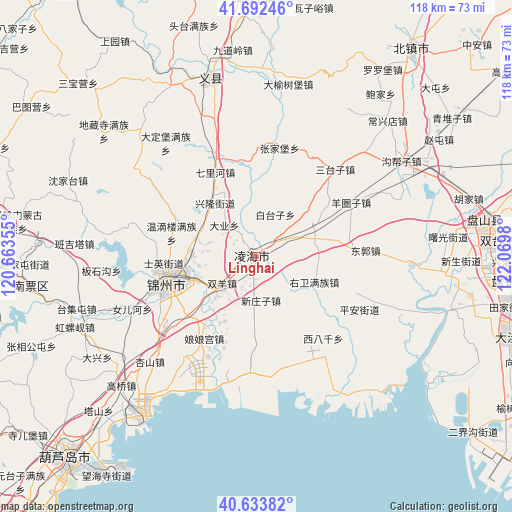
Linghai GPS coordinates[2]
41° 9' 55.008" North, 121° 22' 0.012" East
| Map corner | latitude | longitude |
|---|---|---|
| Upper-left | 41.69246°, | 120.66355° |
| Center: | 41.16528°, | 121.36667° |
| Lower-right: | 40.63382°, | 122.0698° |
| Map W x H: | 117.7×117.7 km | = 73.1×73.1mi |
| max Lat: | 53.31946° ⇑10.5% North |
| Linghai: | 41.16528° |
| min Lat: | ⇓89.5% South 18.22056° |
| min Long | Linghai | max Long |
| 75.07348° | 121.36667° | 134.28917° |
| W 89.4%⇐ | ⇒10.6% E |
Elevation
Elevation of Linghai is 27 m = 89 ft, and this is 457.8 m = 1502 ft below average elevation for this country.
| Max E: |
5622 m = 18445 ft | 79.8% |
| Avg. | 484.8 m = 1591 ft | |
| Linghai | 27 m = 89 ft | |
Min E: |
-3 m = -10 ft | 20.2% |
See also: Linghai elevation on elevation.city.
Geographical zone
Linghai is located in North temperate zone (between Tropic of Cancer and the Arctic Circle). Distance of this Northern Tropic circle is 1971.2 km =1224.8 mi to South.| Distance of | km | miles | from Linghai |
|---|---|---|---|
| North Pole | 5429.9 | 3374 | to North |
| Arctic Circle | 2824 | 1754.8 | to North |
| Tropic Cancer | 1971.2 | 1224.8 | to South |
| Equator | 4577.2 | 2844.1 | to South |


Nearby cities:
15 places around Linghai: (largest is in red/bold)
• Baojia
47 km =29.2 mi,  37°
37°
• Changxingdian
43.5 km =27 mi, 43°
• Daxing
42 km =26.1 mi,  238°
238°
• Gaoqiao
42.9 km =26.7 mi,  226°
226°
• Goubangzi
40.8 km =25.4 mi,  56°
56°
• Jinzhou
19.9 km =12.4 mi,  251°
251°
• Liaotun
48.9 km =30.4 mi, 43°
• Luoluopu
52 km =32.3 mi,  33°
33°
• Lüyang
34.7 km =21.6 mi,  46°
46°
• Nanpiao
52.4 km =32.6 mi,  261°
261°
• Qingduizi
55 km =34.2 mi, 55°
• Taijitun
43.1 km =26.8 mi, 253°
• Wanghu
38.3 km =23.8 mi, 247°
• Yingta
50.7 km =31.5 mi, 225°
• Zhaotun
50.2 km =31.2 mi, 57°
Sources, notices
• [Note1] Compared only with cities in China existing in our database
• [Src1] Map data: © OpenStreetMap contributors (CC-BY-SA)
• [Src2] Other city data from geonames.org with taken over terms of usage.
• [Src3] Geographical zone / Annual Mean Temperature by Robert A. Rohde @ Wikipedia
