Chicheng geodata
Chicheng (Hebei) is a seat of a third-order administrative division; located in China in Asia/Shanghai (GMT+8) time zone. In our database, there are 1268 cities with bigger population. Compared to other cities in China, 88.9% of cities are located further ↓South; 59.1% of cities are located further ←West and 84.3% of cities have lower elevation than Chicheng. Note1


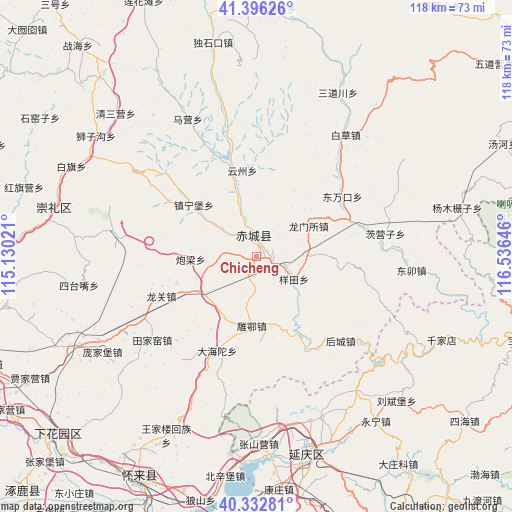
Chicheng GPS coordinates[2]
40° 52' 0.012" North, 115° 49' 59.988" East
| Map corner | latitude | longitude |
|---|---|---|
| Upper-left | 41.39626°, | 115.13021° |
| Center: | 40.86667°, | 115.83333° |
| Lower-right: | 40.33281°, | 116.53646° |
| Map W x H: | 118.2×118.2 km | = 73.4×73.4mi |
| max Lat: | 53.31946° ⇑11.1% North |
| Chicheng: | 40.86667° |
| min Lat: | ⇓88.9% South 18.22056° |
| min Long | Chicheng | max Long |
| 75.07348° | 115.83333° | 134.28917° |
| W 59.1%⇐ | ⇒40.9% E |
Elevation
Elevation of Chicheng is 939 m = 3081 ft, and this is 454.2 m = 1490 ft above average elevation for this country.
| Max E: |
5622 m = 18445 ft | 15.7% |
| Chicheng | 939 m 3081 ft | |
| Avg. | 484.8 m = 1591 ft | |
Min E: |
-3 m = -10 ft | 84.3% |
See also: China elevation on elevation.city.
Geographical zone
Chicheng is located in North temperate zone (between Tropic of Cancer and the Arctic Circle). Distance of this Northern Tropic circle is 1938 km =1204.2 mi to South.| Distance of | km | miles | from Chicheng |
|---|---|---|---|
| North Pole | 5463.1 | 3394.6 | to North |
| Arctic Circle | 2857.2 | 1775.4 | to North |
| Tropic Cancer | 1938 | 1204.2 | to South |
| Equator | 4543.9 | 2823.4 | to South |


Nearby cities:
15 places around Chicheng: (largest is in red/bold)
• Badaling
57.3 km =35.6 mi,  167°
167°
• Dayushu
50.8 km =31.6 mi,  161°
161°
• Dazhuangke
58.1 km =36.1 mi,  145°
145°
• Jingzhuang
49.9 km =31 mi, 154°
• Jiuxian
41.2 km =25.6 mi, 148°
• Kangzhuang
54.6 km =33.9 mi, 174°
• Liubinbu
46.2 km =28.7 mi,  136°
136°
• Qianjiadian
46.9 km =29.1 mi,  114°
114°
• Shacheng
59.4 km =36.9 mi,  207°
207°
• Shenjiaying
45.9 km =28.5 mi, 157°
• Xiangying
42.5 km =26.4 mi, 141°
• Xiwanzi
48.5 km =30.1 mi,  283°
283°
• Yanqing
46.6 km =29 mi, 165°
• Yongning
46.8 km =29.1 mi, 144°
• Zhenzhuquan
60 km =37.3 mi,  125°
125°
Sources, notices
• [Note1] Compared only with cities in China existing in our database
• [Src1] Map data: © OpenStreetMap contributors (CC-BY-SA)
• [Src2] Other city data from geonames.org with taken over terms of usage.
• [Src3] Geographical zone / Annual Mean Temperature by Robert A. Rohde @ Wikipedia
