Shacheng geodata
Shacheng (Hebei) is a seat of a third-order administrative division; located in China in Asia/Shanghai (GMT+8) time zone. In our database, there are 1268 cities with bigger population. Compared to other cities in China, 87.8% of cities are located further ↓South; 57.1% of cities are located further ←West and 74.7% of cities have lower elevation than Shacheng. Note1


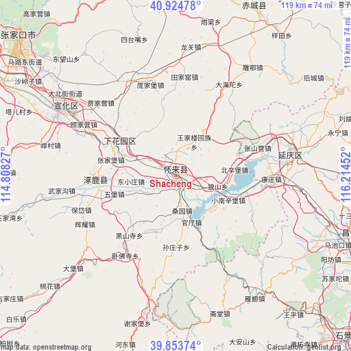
Shacheng GPS coordinates[2]
40° 23' 29.004" North, 115° 30' 41.004" East
| Map corner | latitude | longitude |
|---|---|---|
| Upper-left | 40.92478°, | 114.80827° |
| Center: | 40.39139°, | 115.51139° |
| Lower-right: | 39.85374°, | 116.21452° |
| Map W x H: | 119.1×119.1 km | = 74×74mi |
| max Lat: | 53.31946° ⇑12.2% North |
| Shacheng: | 40.39139° |
| min Lat: | ⇓87.8% South 18.22056° |
| min Long | Shacheng | max Long |
| 75.07348° | 115.51139° | 134.28917° |
| W 57.1%⇐ | ⇒42.9% E |
Elevation
Elevation of Shacheng is 515 m = 1690 ft, and this is 30.2 m = 99 ft above average elevation for this country.
| Max E: |
5622 m = 18445 ft | 25.3% |
| Shacheng | 515 m 1690 ft | |
| Avg. | 484.8 m = 1591 ft | |
Min E: |
-3 m = -10 ft | 74.7% |
See also: China elevation on elevation.city.
Geographical zone
Shacheng is located in North temperate zone (between Tropic of Cancer and the Arctic Circle). Distance of this Northern Tropic circle is 1885.2 km =1171.4 mi to South.| Distance of | km | miles | from Shacheng |
|---|---|---|---|
| North Pole | 5516 | 3427.5 | to North |
| Arctic Circle | 2910.1 | 1808.3 | to North |
| Tropic Cancer | 1885.2 | 1171.4 | to South |
| Equator | 4491.1 | 2790.6 | to South |


Nearby cities:
15 places around Shacheng: (largest is in red/bold)
• Badaling
40.2 km =25 mi,  94°
94°
• Chengzhen
22.8 km =14.2 mi,  295°
295°
• Dayushu
43.4 km =27 mi,  83°
83°
• Jingzhuang
49.7 km =30.9 mi, 80°
• Jiuxian
52 km =32.3 mi,  70°
70°
• Kangzhuang
32.4 km =20.1 mi, 92°
• Qingshui
50.5 km =31.4 mi,  169°
169°
• Shenjiaying
46.2 km =28.7 mi, 76°
• Xibali
15.5 km =9.6 mi, 296°
• Yanchi
49.6 km =30.8 mi,  147°
147°
• Yanjiatai
43.6 km =27.1 mi, 174°
• Yanqing
39.7 km =24.7 mi, 78°
• Zhaitang
49.1 km =30.5 mi,  161°
161°
• Zhangjiakou Shi Xuanhua Qu
46.4 km =28.8 mi, 301°
• Zhuolu
25.1 km =15.6 mi,  264°
264°
Sources, notices
• [Note1] Compared only with cities in China existing in our database
• [Src1] Map data: © OpenStreetMap contributors (CC-BY-SA)
• [Src2] Other city data from geonames.org with taken over terms of usage.
• [Src3] Geographical zone / Annual Mean Temperature by Robert A. Rohde @ Wikipedia
