Changfa geodata
Changfa (Heilongjiang) is a seat of a fourth-order administrative division; located in China in Asia/Shanghai (GMT+8) time zone. In our database, there are 1268 cities with bigger population. Compared to other cities in China, 96.3% of cities are located further ↓South; 99.5% of cities are located further ←West and 54.4% of cities have higher elevation than Changfa. Note1


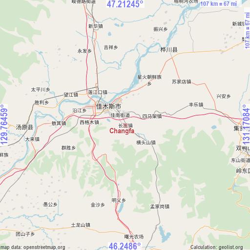
Changfa GPS coordinates[2]
46° 43' 57.648" North, 130° 28' 3.756" East
| Map corner | latitude | longitude |
|---|---|---|
| Upper-left | 47.21245°, | 129.76459° |
| Center: | 46.73268°, | 130.46771° |
| Lower-right: | 46.2486°, | 131.17084° |
| Map W x H: | 107.2×107.2 km | = 66.6×66.6mi |
| max Lat: | 53.31946° ⇑3.7% North |
| Changfa: | 46.73268° |
| min Lat: | ⇓96.3% South 18.22056° |
| min Long | Changfa | max Long |
| 75.07348° | 130.46771° | 134.28917° |
| W 99.5%⇐ | ⇒0.5% E |
Elevation
Elevation of Changfa is 135 m = 443 ft, and this is 349.8 m = 1148 ft below average elevation for this country.
| Max E: |
5622 m = 18445 ft | 54.4% |
| Avg. | 484.8 m = 1591 ft | |
| Changfa | 135 m = 443 ft | |
Min E: |
-3 m = -10 ft | 45.6% |
See also: China elevation on elevation.city.
Geographical zone
Changfa is located in North temperate zone (between Tropic of Cancer and the Arctic Circle). Distance of this North polar circle is 2205 km =1370.1 mi to North.| Distance of | km | miles | from Changfa |
|---|---|---|---|
| North Pole | 4810.9 | 2989.4 | to North |
| Arctic Circle | 2205 | 1370.1 | to North |
| Tropic Cancer | 2590.3 | 1609.5 | to South |
| Equator | 5196.2 | 3228.8 | to South |


Nearby cities:
15 places around Changfa: (largest is in red/bold)
• Changqing
15.5 km =9.6 mi,  299°
299°
• Hengtoushan
11.3 km =7 mi,  128°
128°
• Jiamusi
13.7 km =8.5 mi, 302°
• Jianguo
10.9 km =6.8 mi,  330°
330°
• Jianguo
17 km =10.6 mi,  21°
21°
• Lianjiangkou
18.8 km =11.7 mi,  319°
319°
• Ping’an
19.6 km =12.2 mi, 324°
• Qiaonan
11.5 km =7.1 mi,  313°
313°
• Simajia
12.1 km =7.5 mi,  69°
69°
• Songjiang
11.6 km =7.2 mi,  346°
346°
• Taiping
17.9 km =11.1 mi,  79°
79°
• Xigemu
15.5 km =9.6 mi,  276°
276°
• Yanjiang
20.7 km =12.9 mi,  288°
288°
• Youyi
13.9 km =8.6 mi, 305°
• Zhanqian
10.3 km =6.4 mi, 316°
Sources, notices
• [Note1] Compared only with cities in China existing in our database
• [Src1] Map data: © OpenStreetMap contributors (CC-BY-SA)
• [Src2] Other city data from geonames.org with taken over terms of usage.
• [Src3] Geographical zone / Annual Mean Temperature by Robert A. Rohde @ Wikipedia
