Simajia geodata
Simajia (Heilongjiang) is a seat of a fourth-order administrative division; located in China in Asia/Shanghai (GMT+8) time zone. In our database, there are 1268 cities with bigger population. Compared to other cities in China, 96.5% of cities are located further ↓South; 99.7% of cities are located further ←West and 58.8% of cities have higher elevation than Simajia. Note1


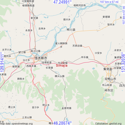
Simajia GPS coordinates[2]
46° 46' 13.728" North, 130° 37' 2.028" East
| Map corner | latitude | longitude |
|---|---|---|
| Upper-left | 47.24991°, | 129.91411° |
| Center: | 46.77048°, | 130.61723° |
| Lower-right: | 46.28674°, | 131.32036° |
| Map W x H: | 107.1×107.1 km | = 66.5×66.5mi |
| max Lat: | 53.31946° ⇑3.5% North |
| Simajia: | 46.77048° |
| min Lat: | ⇓96.5% South 18.22056° |
| min Long | Simajia | max Long |
| 75.07348° | 130.61723° | 134.28917° |
| W 99.7%⇐ | ⇒0.3% E |
Elevation
Elevation of Simajia is 106 m = 348 ft, and this is 378.8 m = 1243 ft below average elevation for this country.
| Max E: |
5622 m = 18445 ft | 58.8% |
| Avg. | 484.8 m = 1591 ft | |
| Simajia | 106 m = 348 ft | |
Min E: |
-3 m = -10 ft | 41.2% |
See also: China elevation on elevation.city.
Geographical zone
Simajia is located in North temperate zone (between Tropic of Cancer and the Arctic Circle). Distance of this North polar circle is 2200.8 km =1367.5 mi to North.| Distance of | km | miles | from Simajia |
|---|---|---|---|
| North Pole | 4806.7 | 2986.7 | to North |
| Arctic Circle | 2200.8 | 1367.5 | to North |
| Tropic Cancer | 2594.5 | 1612.1 | to South |
| Equator | 5200.4 | 3231.4 | to South |


Nearby cities:
15 places around Simajia: (largest is in red/bold)
• Changfa
12.1 km =7.5 mi,  249°
249°
• Changqing
25.1 km =15.6 mi,  277°
277°
• Chuangye
16.3 km =10.1 mi,  7°
7°
• Fengle
19.4 km =12.1 mi,  75°
75°
• Hengtoushan
11.6 km =7.2 mi,  192°
192°
• Jiamusi
23.1 km =14.4 mi, 277°
• Jianguo
12.8 km =8 mi,  335°
335°
• Jianguo
17.6 km =10.9 mi,  287°
287°
• Qiaonan
20.1 km =12.5 mi, 280°
• Songjiang
15.8 km =9.8 mi,  296°
296°
• Sujiadian
19.3 km =12 mi,  40°
40°
• Taiping
6.3 km =3.9 mi,  99°
99°
• Xinghuo
15.6 km =9.7 mi,  356°
356°
• Youyi
23 km =14.3 mi, 279°
• Zhanqian
18.7 km =11.6 mi, 280°
Sources, notices
• [Note1] Compared only with cities in China existing in our database
• [Src1] Map data: © OpenStreetMap contributors (CC-BY-SA)
• [Src2] Other city data from geonames.org with taken over terms of usage.
• [Src3] Geographical zone / Annual Mean Temperature by Robert A. Rohde @ Wikipedia
