Baotou geodata
Baotou (Inner Mongolia) is a populated place; located in China in Asia/Shanghai (GMT+8) time zone. With population of 1,301,768 people, there are 52 cities with bigger population in this country. Compared to other cities in China, 88.4% of cities are located further ↓South; 72.2% of cities are located further →East and 86.3% of cities have lower elevation than Baotou. Note1


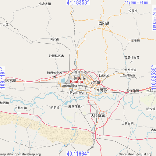
Baotou GPS coordinates[2]
40° 39' 7.992" North, 109° 49' 19.992" East
| Map corner | latitude | longitude |
|---|---|---|
| Upper-left | 41.18353°, | 109.1191° |
| Center: | 40.65222°, | 109.82222° |
| Lower-right: | 40.11664°, | 110.52535° |
| Map W x H: | 118.6×118.6 km | = 73.7×73.7mi |
| max Lat: | 53.31946° ⇑11.6% North |
| Baotou: | 40.65222° |
| min Lat: | ⇓88.4% South 18.22056° |
| min Long | Baotou | max Long |
| 75.07348° | 109.82222° | 134.28917° |
| W 27.8%⇐ | ⇒72.2% E |
Elevation
Elevation of Baotou is 1066 m = 3497 ft, and this is 581.2 m = 1907 ft above average elevation for this country.
| Max E: |
5622 m = 18445 ft | 13.7% |
| Baotou | 1066 m 3497 ft | |
| Avg. | 484.8 m = 1591 ft | |
Min E: |
-3 m = -10 ft | 86.3% |
See also: Baotou elevation on elevation.city.
Geographical zone
Baotou is located in North temperate zone (between Tropic of Cancer and the Arctic Circle). Distance of this Northern Tropic circle is 1914.2 km =1189.4 mi to South.| Distance of | km | miles | from Baotou |
|---|---|---|---|
| North Pole | 5487 | 3409.5 | to North |
| Arctic Circle | 2881.1 | 1790.2 | to North |
| Tropic Cancer | 1914.2 | 1189.4 | to South |
| Equator | 4520.1 | 2808.7 | to South |


Nearby cities:
15 places around Baotou: (largest is in red/bold)
• Bailingnao
78.4 km =48.7 mi,  25°
25°
• Baliang
49.1 km =30.5 mi,  353°
353°
• Damiao
75.5 km =46.9 mi,  49°
49°
• Dongshengyong
49.6 km =30.8 mi, 28°
• Gongyimin
42.1 km =26.2 mi, 26°
• Hujigou
29.7 km =18.5 mi,  44°
44°
• Jihuluntu Sumu
43.6 km =27.1 mi,  70°
70°
• Jinshan
46.6 km =29 mi,  24°
24°
• Salaqi
59.4 km =36.9 mi,  101°
101°
• Shiguai
39.5 km =24.5 mi,  81°
81°
• Shulinzhao
33.6 km =20.9 mi,  149°
149°
• Xiashihao
71.2 km =44.2 mi, 67°
• Xidoupu
63.7 km =39.6 mi,  358°
358°
• Xinjiang
55.8 km =34.7 mi,  57°
57°
• Yinhao
66 km =41 mi, 38°
Sources, notices
• [Note1] Compared only with cities in China existing in our database
• [Src1] Map data: © OpenStreetMap contributors (CC-BY-SA)
• [Src2] Other city data from geonames.org with taken over terms of usage.
• [Src3] Geographical zone / Annual Mean Temperature by Robert A. Rohde @ Wikipedia
