Acheng geodata
Acheng (Heilongjiang) is a seat of a third-order administrative division; located in China in Asia/Shanghai (GMT+8) time zone. With population of 144,665 people, there are 309 cities with bigger population in this country. Compared to other cities in China, 94.4% of cities are located further ↓South; 96.6% of cities are located further ←West and 53.7% of cities have higher elevation than Acheng. Note1


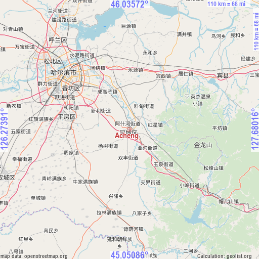
Acheng GPS coordinates[2]
45° 32' 43.62" North, 126° 58' 37.308" East
| Map corner | latitude | longitude |
|---|---|---|
| Upper-left | 46.03572°, | 126.27391° |
| Center: | 45.54545°, | 126.97703° |
| Lower-right: | 45.05086°, | 127.68016° |
| Map W x H: | 109.5×109.5 km | = 68×68mi |
| max Lat: | 53.31946° ⇑5.6% North |
| Acheng: | 45.54545° |
| min Lat: | ⇓94.4% South 18.22056° |
| min Long | Acheng | max Long |
| 75.07348° | 126.97703° | 134.28917° |
| W 96.6%⇐ | ⇒3.4% E |
Elevation
Elevation of Acheng is 139 m = 456 ft, and this is 345.8 m = 1135 ft below average elevation for this country.
| Max E: |
5622 m = 18445 ft | 53.7% |
| Avg. | 484.8 m = 1591 ft | |
| Acheng | 139 m = 456 ft | |
Min E: |
-3 m = -10 ft | 46.3% |
See also: Acheng elevation on elevation.city.
Geographical zone
Acheng is located in North temperate zone (between Tropic of Cancer and the Arctic Circle). Distance of this North polar circle is 2337 km =1452.1 mi to North.| Distance of | km | miles | from Acheng |
|---|---|---|---|
| North Pole | 4942.9 | 3071.4 | to North |
| Arctic Circle | 2337 | 1452.1 | to North |
| Tropic Cancer | 2458.3 | 1527.5 | to South |
| Equator | 5064.2 | 3146.7 | to South |


Nearby cities:
15 places around Acheng: (largest is in red/bold)
• Ashihe
1.1 km =0.7 mi,  193°
193°
• Binxi
26.5 km =16.5 mi,  31°
31°
• Daling
11.4 km =7.1 mi,  112°
112°
• Feiketu
25.9 km =16.1 mi, 30°
• Hongxing
10.7 km =6.6 mi,  77°
77°
• Jiaojie
23.7 km =14.7 mi,  158°
158°
• Liaodian
11.4 km =7.1 mi, 31°
• Sheli
4.4 km =2.7 mi,  298°
298°
• Shuangfeng
11.6 km =7.2 mi,  183°
183°
• Xiangyang
23.5 km =14.6 mi,  349°
349°
• Xinglong
27.9 km =17.3 mi, 192°
• Yagou
10.7 km =6.6 mi,  132°
132°
• Yonghe
33 km =20.5 mi,  17°
17°
• Yongyuan
25.5 km =15.8 mi,  5°
5°
• Yuquan
20.7 km =12.9 mi,  136°
136°
Sources, notices
• [Note1] Compared only with cities in China existing in our database
• [Src1] Map data: © OpenStreetMap contributors (CC-BY-SA)
• [Src2] Other city data from geonames.org with taken over terms of usage.
• [Src3] Geographical zone / Annual Mean Temperature by Robert A. Rohde @ Wikipedia
