Linggou geodata
Linggou (Liaoning) is a seat of a fourth-order administrative division; located in China in Asia/Shanghai (GMT+8) time zone. In our database, there are 1268 cities with bigger population. Compared to other cities in China, 87.1% of cities are located further ↓South; 93.2% of cities are located further ←West and 71.9% of cities have higher elevation than Linggou. Note1


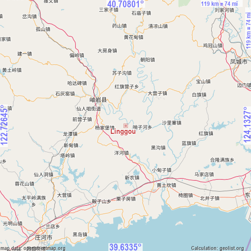
Linggou GPS coordinates[2]
40° 10' 22.368" North, 123° 25' 46.452" East
| Map corner | latitude | longitude |
|---|---|---|
| Upper-left | 40.70801°, | 122.72645° |
| Center: | 40.17288°, | 123.42957° |
| Lower-right: | 39.6335°, | 124.1327° |
| Map W x H: | 119.5×119.5 km | = 74.3×74.3mi |
| max Lat: | 53.31946° ⇑12.9% North |
| Linggou: | 40.17288° |
| min Lat: | ⇓87.1% South 18.22056° |
| min Long | Linggou | max Long |
| 75.07348° | 123.42957° | 134.28917° |
| W 93.2%⇐ | ⇒6.8% E |
Elevation
Elevation of Linggou is 45 m = 148 ft, and this is 439.8 m = 1443 ft below average elevation for this country.
| Max E: |
5622 m = 18445 ft | 71.9% |
| Avg. | 484.8 m = 1591 ft | |
| Linggou | 45 m = 148 ft | |
Min E: |
-3 m = -10 ft | 28.1% |
See also: China elevation on elevation.city.
Geographical zone
Linggou is located in North temperate zone (between Tropic of Cancer and the Arctic Circle). Distance of this Northern Tropic circle is 1860.9 km =1156.3 mi to South.| Distance of | km | miles | from Linggou |
|---|---|---|---|
| North Pole | 5540.3 | 3442.6 | to North |
| Arctic Circle | 2934.4 | 1823.4 | to North |
| Tropic Cancer | 1860.9 | 1156.3 | to South |
| Equator | 4466.8 | 2775.5 | to South |


Nearby cities:
15 places around Linggou: (largest is in red/bold)
• Dayingzi
21.8 km =13.5 mi,  43°
43°
• Hadabei
30 km =18.6 mi,  308°
308°
• Heigou
18.2 km =11.3 mi,  123°
123°
• Hongqi Yingzi
18 km =11.2 mi,  2°
2°
• Qianying
21.2 km =13.2 mi,  265°
265°
• Qianyingzi
21.2 km =13.2 mi,  279°
279°
• Shalizhai
22 km =13.7 mi,  87°
87°
• Suzigou
25.4 km =15.8 mi,  355°
355°
• Xiangrong
26.8 km =16.7 mi,  262°
262°
• Xindian
27.9 km =17.3 mi,  254°
254°
• Xinglong
19.2 km =11.9 mi,  320°
320°
• Xiuyan
18.7 km =11.6 mi, 315°
• Yahe
14.3 km =8.9 mi,  295°
295°
• Yanghe
12.9 km =8 mi,  187°
187°
• Yangjiapu
8.6 km =5.3 mi, 284°
Sources, notices
• [Note1] Compared only with cities in China existing in our database
• [Src1] Map data: © OpenStreetMap contributors (CC-BY-SA)
• [Src2] Other city data from geonames.org with taken over terms of usage.
• [Src3] Geographical zone / Annual Mean Temperature by Robert A. Rohde @ Wikipedia
