Xinglong geodata
Xinglong (Liaoning) is a seat of a fourth-order administrative division; located in China in Asia/Shanghai (GMT+8) time zone. In our database, there are 1268 cities with bigger population. Compared to other cities in China, 87.5% of cities are located further ↓South; 93% of cities are located further ←West and 62.6% of cities have higher elevation than Xinglong. Note1


Xinglong GPS coordinates[2]
40° 18' 21.384" North, 123° 17' 7.764" East
| Map corner | latitude | longitude |
|---|---|---|
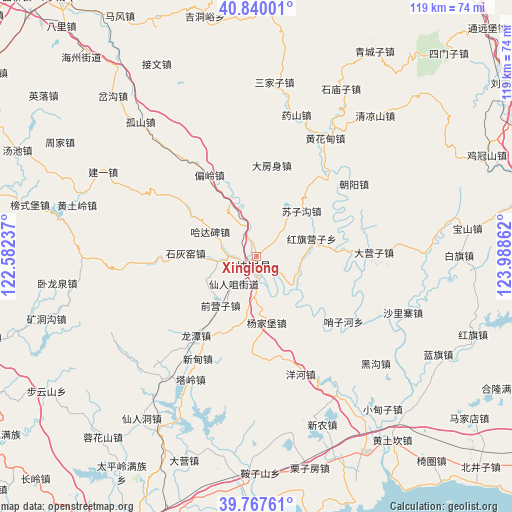
| Upper-left | 40.84001°, | 122.58237° |
| Center: | 40.30594°, | 123.28549° |
| Lower-right: | 39.76761°, | 123.98862° |
| Map W x H: | 119.2×119.2 km | = 74.1×74.1mi |
| max Lat: | 53.31946° ⇑12.5% North |
| Xinglong: | 40.30594° |
| min Lat: | ⇓87.5% South 18.22056° |
| min Long | Xinglong | max Long |
| 75.07348° | 123.28549° | 134.28917° |
| W 93%⇐ | ⇒7% E |
Elevation
Elevation of Xinglong is 84 m = 276 ft, and this is 400.8 m = 1315 ft below average elevation for this country.
| Max E: |
5622 m = 18445 ft | 62.6% |
| Avg. | 484.8 m = 1591 ft | |
| Xinglong | 84 m = 276 ft | |
Min E: |
-3 m = -10 ft | 37.4% |
See also: China elevation on elevation.city.
Geographical zone
Xinglong is located in North temperate zone (between Tropic of Cancer and the Arctic Circle). Distance of this Northern Tropic circle is 1875.7 km =1165.5 mi to South.| Distance of | km | miles | from Xinglong |
|---|---|---|---|
| North Pole | 5525.5 | 3433.4 | to North |
| Arctic Circle | 2919.6 | 1814.2 | to North |
| Tropic Cancer | 1875.7 | 1165.5 | to South |
| Equator | 4481.6 | 2784.7 | to South |


Nearby cities:
15 places around Xinglong: (largest is in red/bold)
• Dafangshen
21.4 km =13.3 mi,  10°
10°
• Dayingzi
27.3 km =17 mi,  88°
88°
• Hadabei
11.8 km =7.3 mi,  289°
289°
• Hongqi Yingzi
13.2 km =8.2 mi,  76°
76°
• Linggou
19.2 km =11.9 mi,  140°
140°
• Pianling
21.9 km =13.6 mi,  330°
330°
• Qianying
18.7 km =11.6 mi,  208°
208°
• Qianyingzi
14.4 km =8.9 mi,  217°
217°
• Shihuiyao
15.3 km =9.5 mi,  272°
272°
• Suzigou
14.8 km =9.2 mi,  44°
44°
• Xiangrong
23.3 km =14.5 mi, 217°
• Xindian
26.5 km =16.5 mi, 213°
• Xiuyan
1.7 km =1.1 mi, 212°
• Yahe
8.7 km =5.4 mi,  184°
184°
• Yangjiapu
13.2 km =8.2 mi,  162°
162°
Sources, notices
• [Note1] Compared only with cities in China existing in our database
• [Src1] Map data: © OpenStreetMap contributors (CC-BY-SA)
• [Src2] Other city data from geonames.org with taken over terms of usage.
• [Src3] Geographical zone / Annual Mean Temperature by Robert A. Rohde @ Wikipedia
