Dayingzi geodata
Dayingzi (Liaoning) is a seat of a fourth-order administrative division; located in China in Asia/Shanghai (GMT+8) time zone. In our database, there are 1268 cities with bigger population. Compared to other cities in China, 87.5% of cities are located further ↓South; 93.3% of cities are located further ←West and 68.7% of cities have higher elevation than Dayingzi. Note1


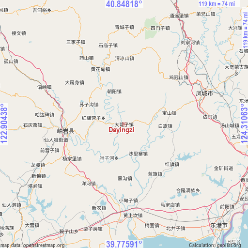
Dayingzi GPS coordinates[2]
40° 18' 51.012" North, 123° 36' 27" East
| Map corner | latitude | longitude |
|---|---|---|
| Upper-left | 40.84818°, | 122.90438° |
| Center: | 40.31417°, | 123.6075° |
| Lower-right: | 39.77591°, | 124.31063° |
| Map W x H: | 119.2×119.2 km | = 74.1×74.1mi |
| max Lat: | 53.31946° ⇑12.5% North |
| Dayingzi: | 40.31417° |
| min Lat: | ⇓87.5% South 18.22056° |
| min Long | Dayingzi | max Long |
| 75.07348° | 123.6075° | 134.28917° |
| W 93.3%⇐ | ⇒6.7% E |
Elevation
Elevation of Dayingzi is 57 m = 187 ft, and this is 427.8 m = 1404 ft below average elevation for this country.
| Max E: |
5622 m = 18445 ft | 68.7% |
| Avg. | 484.8 m = 1591 ft | |
| Dayingzi | 57 m = 187 ft | |
Min E: |
-3 m = -10 ft | 31.3% |
See also: China elevation on elevation.city.
Geographical zone
Dayingzi is located in North temperate zone (between Tropic of Cancer and the Arctic Circle). Distance of this Northern Tropic circle is 1876.6 km =1166.1 mi to South.| Distance of | km | miles | from Dayingzi |
|---|---|---|---|
| North Pole | 5524.5 | 3432.8 | to North |
| Arctic Circle | 2918.7 | 1813.6 | to North |
| Tropic Cancer | 1876.6 | 1166.1 | to South |
| Equator | 4482.5 | 2785.3 | to South |


Nearby cities:
15 places around Dayingzi: (largest is in red/bold)
• Baiqi
19.8 km =12.3 mi,  91°
91°
• Baoshan
22.2 km =13.8 mi,  75°
75°
• Chaoyang
16.6 km =10.3 mi,  343°
343°
• Hanghuadian
29.4 km =18.3 mi, 336°
• Heigou
25.8 km =16 mi,  180°
180°
• Hongqi
29.8 km =18.5 mi,  130°
130°
• Hongqi Yingzi
14.6 km =9.1 mi,  278°
278°
• Lanqi
28 km =17.4 mi,  147°
147°
• Linggou
21.8 km =13.5 mi,  223°
223°
• Shalizhai
16.3 km =10.1 mi,  155°
155°
• Suzigou
19.4 km =12.1 mi,  299°
299°
• Xinglong
27.3 km =17 mi,  268°
268°
• Xiuyan
28.3 km =17.6 mi, 265°
• Yahe
29.6 km =18.4 mi,  251°
251°
• Yangjiapu
27 km =16.8 mi,  240°
240°
Sources, notices
• [Note1] Compared only with cities in China existing in our database
• [Src1] Map data: © OpenStreetMap contributors (CC-BY-SA)
• [Src2] Other city data from geonames.org with taken over terms of usage.
• [Src3] Geographical zone / Annual Mean Temperature by Robert A. Rohde @ Wikipedia
