Heigou geodata
Heigou (Liaoning) is a seat of a fourth-order administrative division; located in China in Asia/Shanghai (GMT+8) time zone. In our database, there are 1268 cities with bigger population. Compared to other cities in China, 86.7% of cities are located further ↓South; 93.3% of cities are located further ←West and 82.1% of cities have higher elevation than Heigou. Note1


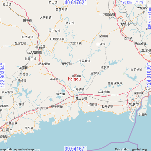
Heigou GPS coordinates[2]
40° 4' 54.372" North, 123° 36' 25.056" East
| Map corner | latitude | longitude |
|---|---|---|
| Upper-left | 40.61762°, | 122.90384° |
| Center: | 40.08177°, | 123.60696° |
| Lower-right: | 39.54167°, | 124.31009° |
| Map W x H: | 119.6×119.6 km | = 74.3×74.3mi |
| max Lat: | 53.31946° ⇑13.3% North |
| Heigou: | 40.08177° |
| min Lat: | ⇓86.7% South 18.22056° |
| min Long | Heigou | max Long |
| 75.07348° | 123.60696° | 134.28917° |
| W 93.3%⇐ | ⇒6.7% E |
Elevation
Elevation of Heigou is 22 m = 72 ft, and this is 462.8 m = 1518 ft below average elevation for this country.
| Max E: |
5622 m = 18445 ft | 82.1% |
| Avg. | 484.8 m = 1591 ft | |
| Heigou | 22 m = 72 ft | |
Min E: |
-3 m = -10 ft | 17.9% |
See also: China elevation on elevation.city.
Geographical zone
Heigou is located in North temperate zone (between Tropic of Cancer and the Arctic Circle). Distance of this Northern Tropic circle is 1850.8 km =1150 mi to South.| Distance of | km | miles | from Heigou |
|---|---|---|---|
| North Pole | 5550.4 | 3448.9 | to North |
| Arctic Circle | 2944.5 | 1829.6 | to North |
| Tropic Cancer | 1850.8 | 1150 | to South |
| Equator | 4456.7 | 2769.3 | to South |


Nearby cities:
15 places around Heigou: (largest is in red/bold)
• Baiqi
32.2 km =20 mi,  38°
38°
• Baoshan
38.1 km =23.7 mi,  34°
34°
• Dayingzi
25.8 km =16 mi,  0°
0°
• Hongqi
23.8 km =14.8 mi,  73°
73°
• Hongqi Yingzi
31.6 km =19.6 mi,  332°
332°
• Lanqi
15.2 km =9.4 mi,  81°
81°
• Linggou
18.2 km =11.3 mi,  303°
303°
• Qianying
37.2 km =23.1 mi,  283°
283°
• Qianyingzi
38.5 km =23.9 mi,  290°
290°
• Shalizhai
13 km =8.1 mi, 31°
• Xinglong
37 km =23 mi,  312°
312°
• Xiuyan
36.7 km =22.8 mi, 309°
• Yahe
32.4 km =20.1 mi, 300°
• Yanghe
17.1 km =10.6 mi,  261°
261°
• Yangjiapu
26.5 km =16.5 mi, 297°
Sources, notices
• [Note1] Compared only with cities in China existing in our database
• [Src1] Map data: © OpenStreetMap contributors (CC-BY-SA)
• [Src2] Other city data from geonames.org with taken over terms of usage.
• [Src3] Geographical zone / Annual Mean Temperature by Robert A. Rohde @ Wikipedia
