Zhenjiang geodata
Zhenjiang (Liaoning) is a seat of a fourth-order administrative division; located in China in Asia/Shanghai (GMT+8) time zone. In our database, there are 1268 cities with bigger population. Compared to other cities in China, 88.6% of cities are located further ↓South; 95% of cities are located further ←West and 53.7% of cities have higher elevation than Zhenjiang. Note1


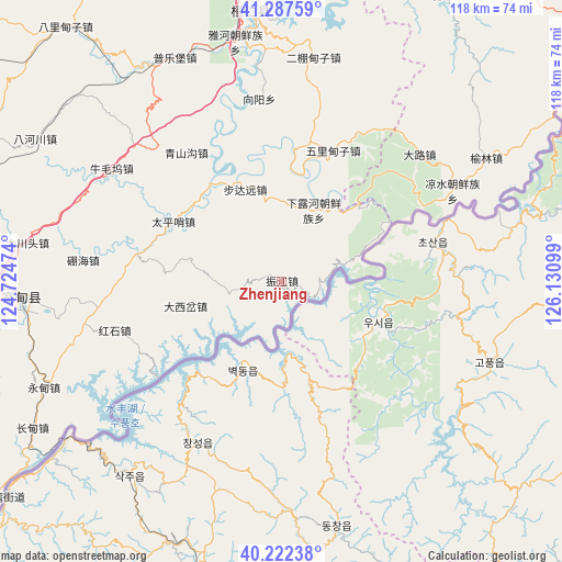
Zhenjiang GPS coordinates[2]
40° 45' 25.632" North, 125° 25' 40.296" East
| Map corner | latitude | longitude |
|---|---|---|
| Upper-left | 41.28759°, | 124.72474° |
| Center: | 40.75712°, | 125.42786° |
| Lower-right: | 40.22238°, | 126.13099° |
| Map W x H: | 118.4×118.4 km | = 73.6×73.6mi |
| max Lat: | 53.31946° ⇑11.4% North |
| Zhenjiang: | 40.75712° |
| min Lat: | ⇓88.6% South 18.22056° |
| min Long | Zhenjiang | max Long |
| 75.07348° | 125.42786° | 134.28917° |
| W 95%⇐ | ⇒5% E |
Elevation
Elevation of Zhenjiang is 139 m = 456 ft, and this is 345.8 m = 1135 ft below average elevation for this country.
| Max E: |
5622 m = 18445 ft | 53.7% |
| Avg. | 484.8 m = 1591 ft | |
| Zhenjiang | 139 m = 456 ft | |
Min E: |
-3 m = -10 ft | 46.3% |
See also: China elevation on elevation.city.
Geographical zone
Zhenjiang is located in North temperate zone (between Tropic of Cancer and the Arctic Circle). Distance of this Northern Tropic circle is 1925.8 km =1196.6 mi to South.| Distance of | km | miles | from Zhenjiang |
|---|---|---|---|
| North Pole | 5475.3 | 3402.2 | to North |
| Arctic Circle | 2869.4 | 1783 | to North |
| Tropic Cancer | 1925.8 | 1196.6 | to South |
| Equator | 4531.8 | 2815.9 | to South |


Nearby cities:
15 places around Zhenjiang: (largest is in red/bold)
• Bahechuan
60 km =37.3 mi,  300°
300°
• Balidianzi
70.1 km =43.6 mi,  319°
319°
• Budayuan
21.2 km =13.2 mi,  337°
337°
• Caiyuan
68.8 km =42.8 mi,  20°
20°
• Dalu
39.2 km =24.4 mi,  47°
47°
• Huadian
67 km =41.6 mi,  25°
25°
• Huanren
56.7 km =35.2 mi,  354°
354°
• Ji’an
74.9 km =46.5 mi,  57°
57°
• Kuandian
54.3 km =33.7 mi,  266°
266°
• Liangshui
40.5 km =25.2 mi, 61°
• Maxian
71.8 km =44.6 mi, 57°
• Minzhu
77.2 km =48 mi, 57°
• Muyuzi
80 km =49.7 mi,  330°
330°
• Taishang
69.5 km =43.2 mi, 29°
• Yulin
50.2 km =31.2 mi, 58°
Sources, notices
• [Note1] Compared only with cities in China existing in our database
• [Src1] Map data: © OpenStreetMap contributors (CC-BY-SA)
• [Src2] Other city data from geonames.org with taken over terms of usage.
• [Src3] Geographical zone / Annual Mean Temperature by Robert A. Rohde @ Wikipedia
