Tiantang geodata
Tiantang (Hunan) is a seat of a fourth-order administrative division; located in China in Asia/Shanghai (GMT+8) time zone. In our database, there are 1268 cities with bigger population. Compared to other cities in China, 84.1% of cities are located further ↑North; 63.2% of cities are located further →East and 56.9% of cities have lower elevation than Tiantang. Note1


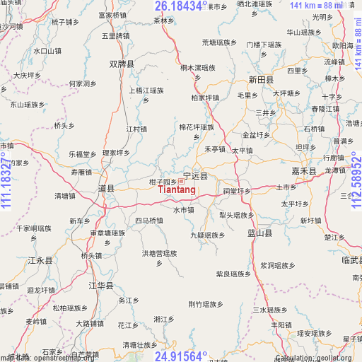
Tiantang GPS coordinates[2]
25° 33' 6.012" North, 111° 53' 11.004" East
| Map corner | latitude | longitude |
|---|---|---|
| Upper-left | 26.18434°, | 111.18327° |
| Center: | 25.55167°, | 111.88639° |
| Lower-right: | 24.91564°, | 112.58952° |
| Map W x H: | 141.1×141.1 km | = 87.7×87.7mi |
| max Lat: | 53.31946° ⇑84.1% North |
| Tiantang: | 25.55167° |
| min Lat: | ⇓15.9% South 18.22056° |
| min Long | Tiantang | max Long |
| 75.07348° | 111.88639° | 134.28917° |
| W 36.8%⇐ | ⇒63.2% E |
Elevation
Elevation of Tiantang is 225 m = 738 ft, and this is 259.8 m = 852 ft below average elevation for this country.
| Max E: |
5622 m = 18445 ft | 43.1% |
| Avg. | 484.8 m = 1591 ft | |
| Tiantang | 225 m = 738 ft | |
Min E: |
-3 m = -10 ft | 56.9% |
See also: China elevation on elevation.city.
Geographical zone
Tiantang is located in North temperate zone (between Tropic of Cancer and the Arctic Circle). Distance of this Northern Tropic circle is 235.2 km =146.1 mi to South.| Distance of | km | miles | from Tiantang |
|---|---|---|---|
| North Pole | 7166 | 4452.7 | to North |
| Arctic Circle | 4560.1 | 2833.5 | to North |
| Tropic Cancer | 235.2 | 146.1 | to South |
| Equator | 2841.1 | 1765.4 | to South |


Nearby cities:
15 places around Tiantang: (largest is in red/bold)
• Baimadu
19.9 km =12.4 mi,  269°
269°
• Baimangpu
18.6 km =11.6 mi,  263°
263°
• Bao’an
27.7 km =17.2 mi,  44°
44°
• Daojiang
30.8 km =19.1 mi, 266°
• Dongmen
28 km =17.4 mi, 263°
• Futang
28.8 km =17.9 mi, 271°
• Hengling
28.5 km =17.7 mi,  213°
213°
• Heting
18 km =11.2 mi,  46°
46°
• Huiyuan
28.4 km =17.6 mi,  132°
132°
• Jiuyi
23.2 km =14.4 mi,  153°
153°
• Lengshui
14.5 km =9 mi,  89°
89°
• Litou
25.2 km =15.7 mi,  120°
120°
• Shunling
6.3 km =3.9 mi, 44°
• Simaqiao
19.6 km =12.2 mi,  219°
219°
• Taiping
26.7 km =16.6 mi,  62°
62°
Sources, notices
• [Note1] Compared only with cities in China existing in our database
• [Src1] Map data: © OpenStreetMap contributors (CC-BY-SA)
• [Src2] Other city data from geonames.org with taken over terms of usage.
• [Src3] Geographical zone / Annual Mean Temperature by Robert A. Rohde @ Wikipedia
