Linhu geodata
Linhu (Jiangsu) is a seat of a fourth-order administrative division; located in China in Asia/Shanghai (GMT+8) time zone. In our database, there are 1268 cities with bigger population. Compared to other cities in China, 55.7% of cities are located further ↓South; 84.8% of cities are located further ←West and 98.9% of cities have higher elevation than Linhu. Note1


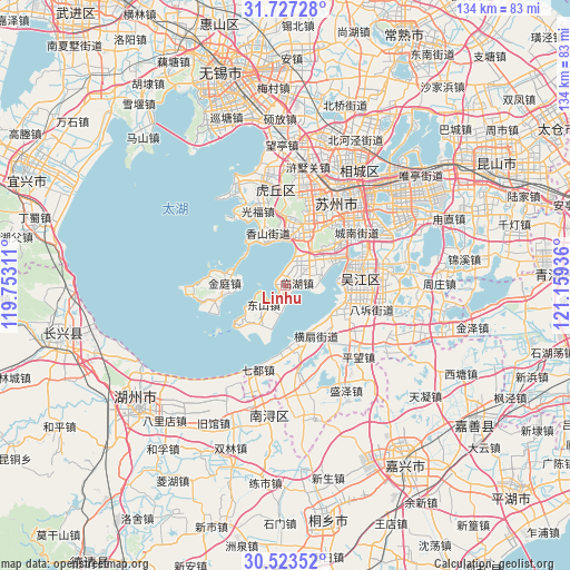
Linhu GPS coordinates[2]
31° 7' 38.316" North, 120° 27' 22.428" East
| Map corner | latitude | longitude |
|---|---|---|
| Upper-left | 31.72728°, | 119.75311° |
| Center: | 31.12731°, | 120.45623° |
| Lower-right: | 30.52352°, | 121.15936° |
| Map W x H: | 133.8×133.8 km | = 83.1×83.1mi |
| max Lat: | 53.31946° ⇑44.3% North |
| Linhu: | 31.12731° |
| min Lat: | ⇓55.7% South 18.22056° |
| min Long | Linhu | max Long |
| 75.07348° | 120.45623° | 134.28917° |
| W 84.8%⇐ | ⇒15.2% E |
Elevation
Elevation of Linhu is 3 m = 10 ft, and this is 481.8 m = 1581 ft below average elevation for this country.
| Max E: |
5622 m = 18445 ft | 98.9% |
| Avg. | 484.8 m = 1591 ft | |
| Linhu | 3 m = 10 ft | |
Min E: |
-3 m = -10 ft | 1.1% |
See also: China elevation on elevation.city.
Geographical zone
Linhu is located in North temperate zone (between Tropic of Cancer and the Arctic Circle). Distance of this Northern Tropic circle is 855.1 km =531.3 mi to South.| Distance of | km | miles | from Linhu |
|---|---|---|---|
| North Pole | 6546 | 4067.5 | to North |
| Arctic Circle | 3940.1 | 2448.3 | to North |
| Tropic Cancer | 855.1 | 531.3 | to South |
| Equator | 3461 | 2150.6 | to South |


Nearby cities:
15 places around Linhu: (largest is in red/bold)
• Dongshan
7.1 km =4.4 mi,  225°
225°
• Dongzhu
23.6 km =14.7 mi,  347°
347°
• Fengqiao
22.5 km =14 mi,  22°
22°
• Guangfu
19 km =11.8 mi,  340°
340°
• Hengjing
8.7 km =5.4 mi,  54°
54°
• Hengshan
14.3 km =8.9 mi,  147°
147°
• Meiyan
20.6 km =12.8 mi,  143°
143°
• Mudu
15.5 km =9.6 mi, 22°
• Qidou
20.5 km =12.7 mi,  198°
198°
• Shishan
21.7 km =13.5 mi,  28°
28°
• Songlong
17.8 km =11.1 mi,  77°
77°
• Xiangshan
12.9 km =8 mi,  334°
334°
• Xishan
14.4 km =8.9 mi,  273°
273°
• Xukou
12.1 km =7.5 mi,  9°
9°
• Yuexi
15.7 km =9.8 mi, 51°
Sources, notices
• [Note1] Compared only with cities in China existing in our database
• [Src1] Map data: © OpenStreetMap contributors (CC-BY-SA)
• [Src2] Other city data from geonames.org with taken over terms of usage.
• [Src3] Geographical zone / Annual Mean Temperature by Robert A. Rohde @ Wikipedia
