Xinfeng geodata
Xinfeng (Anhui) is a seat of a fourth-order administrative division; located in China in Asia/Shanghai (GMT+8) time zone. In our database, there are 1268 cities with bigger population. Compared to other cities in China, 58.4% of cities are located further ↓South; 74.4% of cities are located further ←West and 87.7% of cities have higher elevation than Xinfeng. Note1


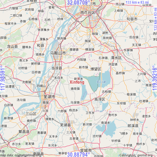
Xinfeng GPS coordinates[2]
31° 29' 21.984" North, 118° 41' 20.508" East
| Map corner | latitude | longitude |
|---|---|---|
| Upper-left | 32.08709°, | 117.98591° |
| Center: | 31.48944°, | 118.68903° |
| Lower-right: | 30.88794°, | 119.39216° |
| Map W x H: | 133.3×133.3 km | = 82.8×82.8mi |
| max Lat: | 53.31946° ⇑41.6% North |
| Xinfeng: | 31.48944° |
| min Lat: | ⇓58.4% South 18.22056° |
| min Long | Xinfeng | max Long |
| 75.07348° | 118.68903° | 134.28917° |
| W 74.4%⇐ | ⇒25.6% E |
Elevation
Elevation of Xinfeng is 12 m = 39 ft, and this is 472.8 m = 1551 ft below average elevation for this country.
| Max E: |
5622 m = 18445 ft | 87.7% |
| Avg. | 484.8 m = 1591 ft | |
| Xinfeng | 12 m = 39 ft | |
Min E: |
-3 m = -10 ft | 12.3% |
See also: China elevation on elevation.city.
Geographical zone
Xinfeng is located in North temperate zone (between Tropic of Cancer and the Arctic Circle). Distance of this Northern Tropic circle is 895.4 km =556.4 mi to South.| Distance of | km | miles | from Xinfeng |
|---|---|---|---|
| North Pole | 6505.8 | 4042.5 | to North |
| Arctic Circle | 3899.9 | 2423.3 | to North |
| Tropic Cancer | 895.4 | 556.4 | to South |
| Equator | 3501.3 | 2175.6 | to South |


Nearby cities:
15 places around Xinfeng: (largest is in red/bold)
• Bowang
16.3 km =10.1 mi,  59°
59°
• Dalong
6.6 km =4.1 mi,  159°
159°
• Danyang
15.7 km =9.8 mi,  9°
9°
• Danyang
17.8 km =11.1 mi, 7°
• Huhe
9.7 km =6 mi,  284°
284°
• Huyang
17.1 km =10.6 mi,  132°
132°
• Longshanqiao
19.6 km =12.2 mi,  272°
272°
• Maqiao
12.1 km =7.5 mi,  222°
222°
• Shiqiao
9.9 km =6.2 mi,  237°
237°
• Taibai
17 km =10.6 mi, 273°
• Tangnan
8.9 km =5.5 mi,  199°
199°
• Wuxi
20.3 km =12.6 mi,  188°
188°
• Xinshi
10.7 km =6.6 mi,  22°
22°
• Xuejin
10.6 km =6.6 mi,  335°
335°
• Yintang
19.6 km =12.2 mi,  309°
309°
Sources, notices
• [Note1] Compared only with cities in China existing in our database
• [Src1] Map data: © OpenStreetMap contributors (CC-BY-SA)
• [Src2] Other city data from geonames.org with taken over terms of usage.
• [Src3] Geographical zone / Annual Mean Temperature by Robert A. Rohde @ Wikipedia
