Tangnan geodata
Tangnan (Anhui) is a seat of a fourth-order administrative division; located in China in Asia/Shanghai (GMT+8) time zone. In our database, there are 1268 cities with bigger population. Compared to other cities in China, 57.9% of cities are located further ↓South; 74.2% of cities are located further ←West and 89.9% of cities have higher elevation than Tangnan. Note1


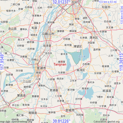
Tangnan GPS coordinates[2]
31° 24' 51.228" North, 118° 39' 28.872" East
| Map corner | latitude | longitude |
|---|---|---|
| Upper-left | 32.01237°, | 117.9549° |
| Center: | 31.41423°, | 118.65802° |
| Lower-right: | 30.81226°, | 119.36115° |
| Map W x H: | 133.4×133.4 km | = 82.9×82.9mi |
| max Lat: | 53.31946° ⇑42.1% North |
| Tangnan: | 31.41423° |
| min Lat: | ⇓57.9% South 18.22056° |
| min Long | Tangnan | max Long |
| 75.07348° | 118.65802° | 134.28917° |
| W 74.2%⇐ | ⇒25.8% E |
Elevation
Elevation of Tangnan is 10 m = 33 ft, and this is 474.8 m = 1558 ft below average elevation for this country.
| Max E: |
5622 m = 18445 ft | 89.9% |
| Avg. | 484.8 m = 1591 ft | |
| Tangnan | 10 m = 33 ft | |
Min E: |
-3 m = -10 ft | 10.1% |
See also: China elevation on elevation.city.
Geographical zone
Tangnan is located in North temperate zone (between Tropic of Cancer and the Arctic Circle). Distance of this Northern Tropic circle is 887 km =551.2 mi to South.| Distance of | km | miles | from Tangnan |
|---|---|---|---|
| North Pole | 6514.1 | 4047.7 | to North |
| Arctic Circle | 3908.2 | 2428.4 | to North |
| Tropic Cancer | 887 | 551.2 | to South |
| Equator | 3492.9 | 2170.4 | to South |


Nearby cities:
15 places around Tangnan: (largest is in red/bold)
• Dalong
5.7 km =3.5 mi,  67°
67°
• Dazha
14.1 km =8.8 mi,  253°
253°
• Huangchi
13.7 km =8.5 mi,  203°
203°
• Huhe
12.6 km =7.8 mi,  328°
328°
• Huyang
15.9 km =9.9 mi,  101°
101°
• Longshanqiao
19 km =11.8 mi,  298°
298°
• Maqiao
5.2 km =3.2 mi,  263°
263°
• Niandou
19.1 km =11.9 mi,  276°
276°
• Shiqiao
6.3 km =3.9 mi, 299°
• Taibai
16.8 km =10.4 mi, 303°
• Wuxi
11.7 km =7.3 mi,  180°
180°
• Xinfeng
8.9 km =5.5 mi,  19°
19°
• Xuejin
18.1 km =11.2 mi,  355°
355°
• Yangjiang
16.8 km =10.4 mi,  122°
122°
• Zhangzhen
17 km =10.6 mi,  225°
225°
Sources, notices
• [Note1] Compared only with cities in China existing in our database
• [Src1] Map data: © OpenStreetMap contributors (CC-BY-SA)
• [Src2] Other city data from geonames.org with taken over terms of usage.
• [Src3] Geographical zone / Annual Mean Temperature by Robert A. Rohde @ Wikipedia
