Xiwai geodata
Xiwai (Sichuan) is a seat of a third-order administrative division; located in China in Asia/Shanghai (GMT+8) time zone. In our database, there are 1268 cities with bigger population. Compared to other cities in China, 56.4% of cities are located further ↓South; 82.3% of cities are located further →East and 64.3% of cities have lower elevation than Xiwai. Note1


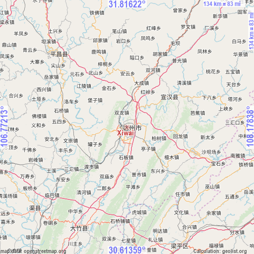
Xiwai GPS coordinates[2]
31° 13' 0.552" North, 107° 28' 30.9" East
| Map corner | latitude | longitude |
|---|---|---|
| Upper-left | 31.81622°, | 106.77213° |
| Center: | 31.21682°, | 107.47525° |
| Lower-right: | 30.61359°, | 108.17838° |
| Map W x H: | 133.7×133.7 km | = 83.1×83.1mi |
| max Lat: | 53.31946° ⇑43.6% North |
| Xiwai: | 31.21682° |
| min Lat: | ⇓56.4% South 18.22056° |
| min Long | Xiwai | max Long |
| 75.07348° | 107.47525° | 134.28917° |
| W 17.7%⇐ | ⇒82.3% E |
Elevation
Elevation of Xiwai is 314 m = 1030 ft, and this is 170.8 m = 560 ft below average elevation for this country.
| Max E: |
5622 m = 18445 ft | 35.7% |
| Avg. | 484.8 m = 1591 ft | |
| Xiwai | 314 m = 1030 ft | |
Min E: |
-3 m = -10 ft | 64.3% |
See also: China elevation on elevation.city.
Geographical zone
Xiwai is located in North temperate zone (between Tropic of Cancer and the Arctic Circle). Distance of this Northern Tropic circle is 865.1 km =537.5 mi to South.| Distance of | km | miles | from Xiwai |
|---|---|---|---|
| North Pole | 6536.1 | 4061.3 | to North |
| Arctic Circle | 3930.2 | 2442.1 | to North |
| Tropic Cancer | 865.1 | 537.5 | to South |
| Equator | 3471 | 2156.8 | to South |


Nearby cities:
15 places around Xiwai: (largest is in red/bold)
• Bishan
49.6 km =30.8 mi,  181°
181°
• Dazhou
2.4 km =1.5 mi,  92°
92°
• Hucheng
45.1 km =28 mi,  171°
171°
• Jiangkou
52.8 km =32.8 mi,  317°
317°
• Longmen
50.7 km =31.5 mi,  156°
156°
• Longsheng
49.6 km =30.8 mi, 171°
• Mingda
57.2 km =35.5 mi, 162°
• Nanwai
3 km =1.9 mi,  116°
116°
• Wenhua
53.1 km =33 mi,  147°
147°
• Wushan
54.6 km =33.9 mi, 124°
• Xinning
39.9 km =24.8 mi,  111°
111°
• Xinsheng
47.8 km =29.7 mi, 150°
• Yihe
58.1 km =36.1 mi,  96°
96°
• Yuanyi
53 km =32.9 mi, 176°
• Zhushan
56.3 km =35 mi, 170°
Sources, notices
• [Note1] Compared only with cities in China existing in our database
• [Src1] Map data: © OpenStreetMap contributors (CC-BY-SA)
• [Src2] Other city data from geonames.org with taken over terms of usage.
• [Src3] Geographical zone / Annual Mean Temperature by Robert A. Rohde @ Wikipedia
