Jiangkou geodata
Jiangkou (Sichuan) is a seat of a third-order administrative division; located in China in Asia/Shanghai (GMT+8) time zone. In our database, there are 1268 cities with bigger population. Compared to other cities in China, 58.8% of cities are located further ↓South; 83.4% of cities are located further →East and 68.1% of cities have lower elevation than Jiangkou. Note1


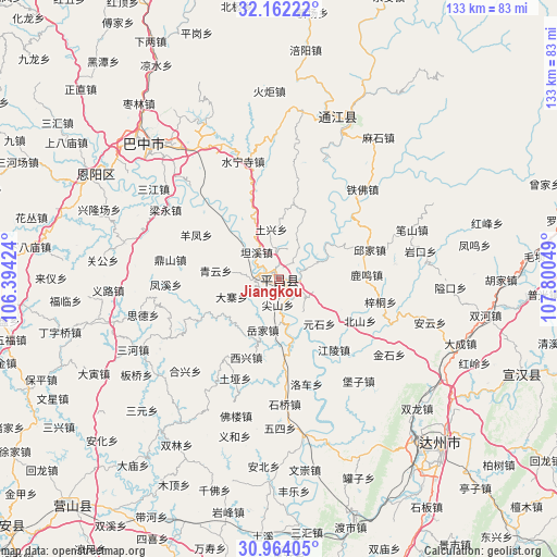
Jiangkou GPS coordinates[2]
31° 33' 54.216" North, 107° 5' 50.496" East
| Map corner | latitude | longitude |
|---|---|---|
| Upper-left | 32.16222°, | 106.39424° |
| Center: | 31.56506°, | 107.09736° |
| Lower-right: | 30.96405°, | 107.80049° |
| Map W x H: | 133.2×133.2 km | = 82.8×82.8mi |
| max Lat: | 53.31946° ⇑41.2% North |
| Jiangkou: | 31.56506° |
| min Lat: | ⇓58.8% South 18.22056° |
| min Long | Jiangkou | max Long |
| 75.07348° | 107.09736° | 134.28917° |
| W 16.6%⇐ | ⇒83.4% E |
Elevation
Elevation of Jiangkou is 379 m = 1243 ft, and this is 105.8 m = 347 ft below average elevation for this country.
| Max E: |
5622 m = 18445 ft | 31.9% |
| Avg. | 484.8 m = 1591 ft | |
| Jiangkou | 379 m = 1243 ft | |
Min E: |
-3 m = -10 ft | 68.1% |
See also: China elevation on elevation.city.
Geographical zone
Jiangkou is located in North temperate zone (between Tropic of Cancer and the Arctic Circle). Distance of this Northern Tropic circle is 903.8 km =561.6 mi to South.| Distance of | km | miles | from Jiangkou |
|---|---|---|---|
| North Pole | 6497.4 | 4037.3 | to North |
| Arctic Circle | 3891.5 | 2418.1 | to North |
| Tropic Cancer | 903.8 | 561.6 | to South |
| Equator | 3509.7 | 2180.8 | to South |


Nearby cities:
15 places around Jiangkou: (largest is in red/bold)
• Bazhong
47.5 km =29.5 mi,  315°
315°
• Bazhou
44.6 km =27.7 mi, 316°
• Chixi
72.7 km =45.2 mi,  334°
334°
• Dahe
71.8 km =44.6 mi,  347°
347°
• Dazhou
54.5 km =33.9 mi,  135°
135°
• Fujia
72.5 km =45 mi, 327°
• Gaoqiao
63.6 km =39.5 mi,  337°
337°
• Heitan
66.9 km =41.6 mi, 321°
• Heping
74 km =46 mi, 316°
• Langchi
74 km =46 mi,  223°
223°
• Nanwai
55.6 km =34.5 mi, 136°
• Nuojiang
41.3 km =25.7 mi,  19°
19°
• Pinggang
62.1 km =38.6 mi, 341°
• Xialiang
64.7 km =40.2 mi, 331°
• Xiwai
52.8 km =32.8 mi, 137°
Sources, notices
• [Note1] Compared only with cities in China existing in our database
• [Src1] Map data: © OpenStreetMap contributors (CC-BY-SA)
• [Src2] Other city data from geonames.org with taken over terms of usage.
• [Src3] Geographical zone / Annual Mean Temperature by Robert A. Rohde @ Wikipedia
