Pianbai geodata
Pianbai (Chongqing) is a seat of a fourth-order administrative division; located in China in Asia/Shanghai (GMT+8) time zone. In our database, there are 1268 cities with bigger population. Compared to other cities in China, 65.1% of cities are located further ↑North; 75.9% of cities are located further →East and 65.2% of cities have lower elevation than Pianbai. Note1


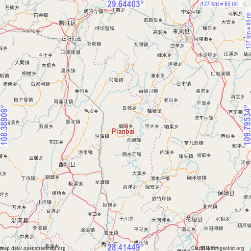
Pianbai GPS coordinates[2]
29° 1' 51.924" North, 109° 5' 31.956" East
| Map corner | latitude | longitude |
|---|---|---|
| Upper-left | 29.64403°, | 108.38909° |
| Center: | 29.03109°, | 109.09221° |
| Lower-right: | 28.41449°, | 109.79534° |
| Map W x H: | 136.7×136.7 km | = 84.9×84.9mi |
| max Lat: | 53.31946° ⇑65.1% North |
| Pianbai: | 29.03109° |
| min Lat: | ⇓34.9% South 18.22056° |
| min Long | Pianbai | max Long |
| 75.07348° | 109.09221° | 134.28917° |
| W 24.1%⇐ | ⇒75.9% E |
Elevation
Elevation of Pianbai is 329 m = 1079 ft, and this is 155.8 m = 511 ft below average elevation for this country.
| Max E: |
5622 m = 18445 ft | 34.8% |
| Avg. | 484.8 m = 1591 ft | |
| Pianbai | 329 m = 1079 ft | |
Min E: |
-3 m = -10 ft | 65.2% |
See also: China elevation on elevation.city.
Geographical zone
Pianbai is located in North temperate zone (between Tropic of Cancer and the Arctic Circle). Distance of this Northern Tropic circle is 622 km =386.5 mi to South.| Distance of | km | miles | from Pianbai |
|---|---|---|---|
| North Pole | 6779.1 | 4212.3 | to North |
| Arctic Circle | 4173.2 | 2593.1 | to North |
| Tropic Cancer | 622 | 386.5 | to South |
| Equator | 3228 | 2005.8 | to South |


Nearby cities:
15 places around Pianbai: (largest is in red/bold)
• Baifusi
22.9 km =14.2 mi,  32°
32°
• Bamian
22.4 km =13.9 mi,  135°
135°
• Chetian
13.1 km =8.1 mi,  340°
340°
• Daxi
8.9 km =5.5 mi,  37°
37°
• Ganxi
14 km =8.7 mi,  246°
246°
• Guitangba
18.4 km =11.4 mi,  61°
61°
• Houxi
15.8 km =9.8 mi,  167°
167°
• Keda
14.4 km =8.9 mi,  90°
90°
• Maoba
20.4 km =12.7 mi,  293°
293°
• Mawang
20.6 km =12.8 mi,  221°
221°
• Tushi
25.3 km =15.7 mi,  240°
240°
• Wufu
10.4 km =6.5 mi,  13°
13°
• Youchou
8.9 km =5.5 mi,  147°
147°
• Yudi
17.5 km =10.9 mi,  259°
259°
• Zanguoping
24.9 km =15.5 mi, 91°
Sources, notices
• [Note1] Compared only with cities in China existing in our database
• [Src1] Map data: © OpenStreetMap contributors (CC-BY-SA)
• [Src2] Other city data from geonames.org with taken over terms of usage.
• [Src3] Geographical zone / Annual Mean Temperature by Robert A. Rohde @ Wikipedia
