Guitangba geodata
Guitangba (Hunan) is a seat of a fourth-order administrative division; located in China in Asia/Shanghai (GMT+8) time zone. In our database, there are 1268 cities with bigger population. Compared to other cities in China, 64.2% of cities are located further ↑North; 75.1% of cities are located further →East and 70.7% of cities have lower elevation than Guitangba. Note1


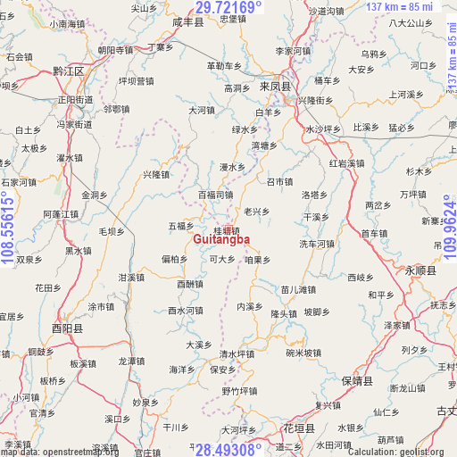
Guitangba GPS coordinates[2]
29° 6' 33.192" North, 109° 15' 33.372" East
| Map corner | latitude | longitude |
|---|---|---|
| Upper-left | 29.72169°, | 108.55615° |
| Center: | 29.10922°, | 109.25927° |
| Lower-right: | 28.49308°, | 109.9624° |
| Map W x H: | 136.6×136.6 km | = 84.9×84.9mi |
| max Lat: | 53.31946° ⇑64.2% North |
| Guitangba: | 29.10922° |
| min Lat: | ⇓35.8% South 18.22056° |
| min Long | Guitangba | max Long |
| 75.07348° | 109.25927° | 134.28917° |
| W 24.9%⇐ | ⇒75.1% E |
Elevation
Elevation of Guitangba is 425 m = 1394 ft, and this is 59.8 m = 196 ft below average elevation for this country.
| Max E: |
5622 m = 18445 ft | 29.3% |
| Avg. | 484.8 m = 1591 ft | |
| Guitangba | 425 m = 1394 ft | |
Min E: |
-3 m = -10 ft | 70.7% |
See also: China elevation on elevation.city.
Geographical zone
Guitangba is located in North temperate zone (between Tropic of Cancer and the Arctic Circle). Distance of this Northern Tropic circle is 630.7 km =391.9 mi to South.| Distance of | km | miles | from Guitangba |
|---|---|---|---|
| North Pole | 6770.4 | 4206.9 | to North |
| Arctic Circle | 4164.5 | 2587.7 | to North |
| Tropic Cancer | 630.7 | 391.9 | to South |
| Equator | 3236.6 | 2011.1 | to South |


Nearby cities:
15 places around Guitangba: (largest is in red/bold)
• Baifusi
11.2 km =7 mi,  339°
339°
• Chetian
21 km =13 mi,  279°
279°
• Daxi
10.9 km =6.8 mi,  261°
261°
• Jiajiaba
12.8 km =8 mi,  72°
72°
• Jiashi
20.7 km =12.9 mi,  137°
137°
• Keda
9.1 km =5.7 mi,  191°
191°
• Laoxingchang
9.7 km =6 mi,  57°
57°
• Liangshuijing
20 km =12.4 mi,  4°
4°
• Mengxihu
21.3 km =13.2 mi,  86°
86°
• Pianbai
18.4 km =11.4 mi,  241°
241°
• Piduhe
15.2 km =9.4 mi,  21°
21°
• Wufu
13.8 km =8.6 mi, 275°
• Youchou
19.8 km =12.3 mi,  215°
215°
• Zanguoping
12.7 km =7.9 mi, 136°
• Zhaoshi
21.4 km =13.3 mi,  48°
48°
Sources, notices
• [Note1] Compared only with cities in China existing in our database
• [Src1] Map data: © OpenStreetMap contributors (CC-BY-SA)
• [Src2] Other city data from geonames.org with taken over terms of usage.
• [Src3] Geographical zone / Annual Mean Temperature by Robert A. Rohde @ Wikipedia
