Daxi geodata
Daxi (Chongqing) is a seat of a fourth-order administrative division; located in China in Asia/Shanghai (GMT+8) time zone. In our database, there are 1268 cities with bigger population. Compared to other cities in China, 64.4% of cities are located further ↑North; 75.6% of cities are located further →East and 68.9% of cities have lower elevation than Daxi. Note1


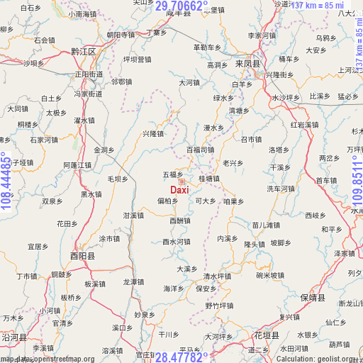
Daxi GPS coordinates[2]
29° 5' 38.58" North, 109° 8' 52.692" East
| Map corner | latitude | longitude |
|---|---|---|
| Upper-left | 29.70662°, | 108.44485° |
| Center: | 29.09405°, | 109.14797° |
| Lower-right: | 28.47782°, | 109.8511° |
| Map W x H: | 136.6×136.6 km | = 84.9×84.9mi |
| max Lat: | 53.31946° ⇑64.4% North |
| Daxi: | 29.09405° |
| min Lat: | ⇓35.6% South 18.22056° |
| min Long | Daxi | max Long |
| 75.07348° | 109.14797° | 134.28917° |
| W 24.4%⇐ | ⇒75.6% E |
Elevation
Elevation of Daxi is 391 m = 1283 ft, and this is 93.8 m = 308 ft below average elevation for this country.
| Max E: |
5622 m = 18445 ft | 31.1% |
| Avg. | 484.8 m = 1591 ft | |
| Daxi | 391 m = 1283 ft | |
Min E: |
-3 m = -10 ft | 68.9% |
See also: China elevation on elevation.city.
Geographical zone
Daxi is located in North temperate zone (between Tropic of Cancer and the Arctic Circle). Distance of this Northern Tropic circle is 629 km =390.8 mi to South.| Distance of | km | miles | from Daxi |
|---|---|---|---|
| North Pole | 6772.1 | 4208 | to North |
| Arctic Circle | 4166.2 | 2588.8 | to North |
| Tropic Cancer | 629 | 390.8 | to South |
| Equator | 3235 | 2010.1 | to South |


Nearby cities:
15 places around Daxi: (largest is in red/bold)
• Baifusi
14.1 km =8.8 mi,  29°
29°
• Chetian
11.2 km =7 mi,  298°
298°
• Ganxi
22.2 km =13.8 mi,  235°
235°
• Guitangba
10.9 km =6.8 mi,  81°
81°
• Houxi
22.5 km =14 mi,  185°
185°
• Jiajiaba
23.6 km =14.7 mi, 76°
• Keda
11.6 km =7.2 mi,  128°
128°
• Laoxingchang
20.2 km =12.6 mi,  70°
70°
• Muye
23.7 km =14.7 mi,  319°
319°
• Pianbai
8.9 km =5.5 mi,  217°
217°
• Piduhe
22.8 km =14.2 mi,  45°
45°
• Wufu
4.3 km =2.7 mi, 316°
• Xinglong
21.2 km =13.2 mi,  329°
329°
• Youchou
14.5 km =9 mi,  182°
182°
• Zanguoping
20.9 km =13 mi,  111°
111°
Sources, notices
• [Note1] Compared only with cities in China existing in our database
• [Src1] Map data: © OpenStreetMap contributors (CC-BY-SA)
• [Src2] Other city data from geonames.org with taken over terms of usage.
• [Src3] Geographical zone / Annual Mean Temperature by Robert A. Rohde @ Wikipedia
