Keda geodata
Keda (Chongqing) is a seat of a fourth-order administrative division; located in China in Asia/Shanghai (GMT+8) time zone. In our database, there are 1268 cities with bigger population. Compared to other cities in China, 65.1% of cities are located further ↑North; 75.2% of cities are located further →East and 75% of cities have lower elevation than Keda. Note1


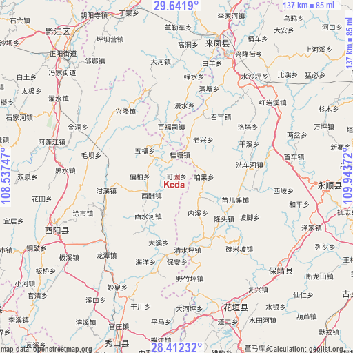
Keda GPS coordinates[2]
29° 1' 44.184" North, 109° 14' 26.124" East
| Map corner | latitude | longitude |
|---|---|---|
| Upper-left | 29.6419°, | 108.53747° |
| Center: | 29.02894°, | 109.24059° |
| Lower-right: | 28.41232°, | 109.94372° |
| Map W x H: | 136.7×136.7 km | = 84.9×84.9mi |
| max Lat: | 53.31946° ⇑65.1% North |
| Keda: | 29.02894° |
| min Lat: | ⇓34.9% South 18.22056° |
| min Long | Keda | max Long |
| 75.07348° | 109.24059° | 134.28917° |
| W 24.8%⇐ | ⇒75.2% E |
Elevation
Elevation of Keda is 522 m = 1713 ft, and this is 37.2 m = 122 ft above average elevation for this country.
| Max E: |
5622 m = 18445 ft | 25% |
| Keda | 522 m 1713 ft | |
| Avg. | 484.8 m = 1591 ft | |
Min E: |
-3 m = -10 ft | 75% |
See also: China elevation on elevation.city.
Geographical zone
Keda is located in North temperate zone (between Tropic of Cancer and the Arctic Circle). Distance of this Northern Tropic circle is 621.8 km =386.4 mi to South.| Distance of | km | miles | from Keda |
|---|---|---|---|
| North Pole | 6779.3 | 4212.5 | to North |
| Arctic Circle | 4173.5 | 2593.3 | to North |
| Tropic Cancer | 621.8 | 386.4 | to South |
| Equator | 3227.7 | 2005.6 | to South |


Nearby cities:
15 places around Keda: (largest is in red/bold)
• Baifusi
19.6 km =12.2 mi,  353°
353°
• Bamian
15.7 km =9.8 mi,  175°
175°
• Chetian
22.7 km =14.1 mi,  303°
303°
• Daxi
11.6 km =7.2 mi,  308°
308°
• Fengxizhai
20.1 km =12.5 mi,  97°
97°
• Guitangba
9.1 km =5.7 mi,  11°
11°
• Houxi
18.7 km =11.6 mi,  216°
216°
• Jiajiaba
19 km =11.8 mi,  47°
47°
• Jiashi
16.9 km =10.5 mi,  112°
112°
• Laoxingchang
17.3 km =10.7 mi,  35°
35°
• Neixi
16 km =9.9 mi,  149°
149°
• Pianbai
14.4 km =8.9 mi,  270°
270°
• Wufu
15.8 km =9.8 mi, 310°
• Youchou
12.1 km =7.5 mi,  232°
232°
• Zanguoping
10.5 km =6.5 mi,  91°
91°
Sources, notices
• [Note1] Compared only with cities in China existing in our database
• [Src1] Map data: © OpenStreetMap contributors (CC-BY-SA)
• [Src2] Other city data from geonames.org with taken over terms of usage.
• [Src3] Geographical zone / Annual Mean Temperature by Robert A. Rohde @ Wikipedia
