Dahe geodata
Dahe (Hubei) is a seat of a fourth-order administrative division; located in China in Asia/Shanghai (GMT+8) time zone. In our database, there are 1268 cities with bigger population. Compared to other cities in China, 60.5% of cities are located further ↑North; 75.5% of cities are located further →East and 75.7% of cities have lower elevation than Dahe. Note1


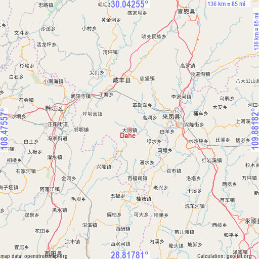
Dahe GPS coordinates[2]
29° 25' 55.308" North, 109° 10' 43.284" East
| Map corner | latitude | longitude |
|---|---|---|
| Upper-left | 30.04255°, | 108.47557° |
| Center: | 29.43203°, | 109.17869° |
| Lower-right: | 28.81781°, | 109.88182° |
| Map W x H: | 136.2×136.2 km | = 84.6×84.6mi |
| max Lat: | 53.31946° ⇑60.5% North |
| Dahe: | 29.43203° |
| min Lat: | ⇓39.5% South 18.22056° |
| min Long | Dahe | max Long |
| 75.07348° | 109.17869° | 134.28917° |
| W 24.5%⇐ | ⇒75.5% E |
Elevation
Elevation of Dahe is 536 m = 1759 ft, and this is 51.2 m = 168 ft above average elevation for this country.
| Max E: |
5622 m = 18445 ft | 24.3% |
| Dahe | 536 m 1759 ft | |
| Avg. | 484.8 m = 1591 ft | |
Min E: |
-3 m = -10 ft | 75.7% |
See also: China elevation on elevation.city.
Geographical zone
Dahe is located in North temperate zone (between Tropic of Cancer and the Arctic Circle). Distance of this Northern Tropic circle is 666.6 km =414.2 mi to South.| Distance of | km | miles | from Dahe |
|---|---|---|---|
| North Pole | 6734.5 | 4184.6 | to North |
| Arctic Circle | 4128.6 | 2565.4 | to North |
| Tropic Cancer | 666.6 | 414.2 | to South |
| Equator | 3272.5 | 2033.4 | to South |


Nearby cities:
15 places around Dahe: (largest is in red/bold)
• Baifusi
25.7 km =16 mi,  171°
171°
• Cengjiawan
19.1 km =11.9 mi,  93°
93°
• Dingzhai
22.4 km =13.9 mi,  326°
326°
• Geleche
14.7 km =9.1 mi,  26°
26°
• Hujiagou
21.1 km =13.1 mi,  41°
41°
• Jiamachi
21.4 km =13.3 mi,  293°
293°
• Jiusi
7.4 km =4.6 mi, 88°
• Liangshuijing
18.6 km =11.6 mi,  149°
149°
• Longzui
21.3 km =13.2 mi,  120°
120°
• Min’an
25.2 km =15.7 mi,  83°
83°
• Muye
26.9 km =16.7 mi,  223°
223°
• Piduhe
25.5 km =15.8 mi, 148°
• Shangzhai
13.2 km =8.2 mi, 116°
• Xiangfeng
23.3 km =14.5 mi,  68°
68°
• Xinglong
23.7 km =14.7 mi, 215°
Sources, notices
• [Note1] Compared only with cities in China existing in our database
• [Src1] Map data: © OpenStreetMap contributors (CC-BY-SA)
• [Src2] Other city data from geonames.org with taken over terms of usage.
• [Src3] Geographical zone / Annual Mean Temperature by Robert A. Rohde @ Wikipedia
