Leba geodata
Leba (Sichuan) is a seat of a fourth-order administrative division; located in China in Asia/Shanghai (GMT+8) time zone. In our database, there are 1268 cities with bigger population. Compared to other cities in China, 62.8% of cities are located further ↓South; 84.6% of cities are located further →East and 73% of cities have lower elevation than Leba. Note1


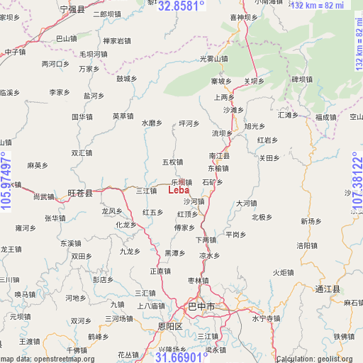
Leba GPS coordinates[2]
32° 15' 55.8" North, 106° 40' 41.124" East
| Map corner | latitude | longitude |
|---|---|---|
| Upper-left | 32.8581°, | 105.97497° |
| Center: | 32.2655°, | 106.67809° |
| Lower-right: | 31.66901°, | 107.38122° |
| Map W x H: | 132.2×132.2 km | = 82.1×82.1mi |
| max Lat: | 53.31946° ⇑37.2% North |
| Leba: | 32.2655° |
| min Lat: | ⇓62.8% South 18.22056° |
| min Long | Leba | max Long |
| 75.07348° | 106.67809° | 134.28917° |
| W 15.4%⇐ | ⇒84.6% E |
Elevation
Elevation of Leba is 475 m = 1558 ft, and this is 9.8 m = 32 ft below average elevation for this country.
| Max E: |
5622 m = 18445 ft | 27% |
| Avg. | 484.8 m = 1591 ft | |
| Leba | 475 m = 1558 ft | |
Min E: |
-3 m = -10 ft | 73% |
See also: China elevation on elevation.city.
Geographical zone
Leba is located in North temperate zone (between Tropic of Cancer and the Arctic Circle). Distance of this Northern Tropic circle is 981.7 km =610 mi to South.| Distance of | km | miles | from Leba |
|---|---|---|---|
| North Pole | 6419.5 | 3988.9 | to North |
| Arctic Circle | 3813.6 | 2369.7 | to North |
| Tropic Cancer | 981.7 | 610 | to South |
| Equator | 3587.6 | 2229.2 | to South |


Nearby cities:
15 places around Leba: (largest is in red/bold)
• Changchi
11.5 km =7.1 mi,  189°
189°
• Chixi
14.8 km =9.2 mi,  146°
146°
• Dongyu
14.3 km =8.9 mi,  68°
68°
• Fujia
16.5 km =10.3 mi,  176°
176°
• Gaoqiao
24.3 km =15.1 mi,  142°
142°
• Jinxi
3.1 km =1.9 mi,  321°
321°
• Mumen
22.4 km =13.9 mi,  219°
219°
• Nanjiang
17.5 km =10.9 mi,  55°
55°
• Nianpan
19.4 km =12.1 mi,  54°
54°
• Puji
21.2 km =13.2 mi,  262°
262°
• Sanjiang
13.2 km =8.2 mi, 256°
• Shahe
8.3 km =5.2 mi, 147°
• Tuanjie
6.4 km =4 mi, 66°
• Wuquan
8.1 km =5 mi,  335°
335°
• Xialiang
22.8 km =14.2 mi,  157°
157°
Sources, notices
• [Note1] Compared only with cities in China existing in our database
• [Src1] Map data: © OpenStreetMap contributors (CC-BY-SA)
• [Src2] Other city data from geonames.org with taken over terms of usage.
• [Src3] Geographical zone / Annual Mean Temperature by Robert A. Rohde @ Wikipedia
