Puji geodata
Puji (Sichuan) is a seat of a fourth-order administrative division; located in China in Asia/Shanghai (GMT+8) time zone. With population of 2,000 people, there are 1030 cities with bigger population in this country. Compared to other cities in China, 62.7% of cities are located further ↓South; 85.3% of cities are located further →East and 74.4% of cities have lower elevation than Puji. Note1


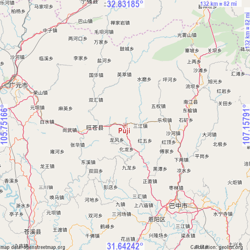
Puji GPS coordinates[2]
32° 14' 20.688" North, 106° 27' 17.208" East
| Map corner | latitude | longitude |
|---|---|---|
| Upper-left | 32.83185°, | 105.75166° |
| Center: | 32.23908°, | 106.45478° |
| Lower-right: | 31.64242°, | 107.15791° |
| Map W x H: | 132.3×132.3 km | = 82.2×82.2mi |
| max Lat: | 53.31946° ⇑37.3% North |
| Puji: | 32.23908° |
| min Lat: | ⇓62.7% South 18.22056° |
| min Long | Puji | max Long |
| 75.07348° | 106.45478° | 134.28917° |
| W 14.7%⇐ | ⇒85.3% E |
Elevation
Elevation of Puji is 509 m = 1670 ft, and this is 24.2 m = 79 ft above average elevation for this country.
| Max E: |
5622 m = 18445 ft | 25.6% |
| Puji | 509 m 1670 ft | |
| Avg. | 484.8 m = 1591 ft | |
Min E: |
-3 m = -10 ft | 74.4% |
See also: China elevation on elevation.city.
Geographical zone
Puji is located in North temperate zone (between Tropic of Cancer and the Arctic Circle). Distance of this Northern Tropic circle is 978.7 km =608.1 mi to South.| Distance of | km | miles | from Puji |
|---|---|---|---|
| North Pole | 6422.4 | 3990.7 | to North |
| Arctic Circle | 3816.5 | 2371.5 | to North |
| Tropic Cancer | 978.7 | 608.1 | to South |
| Equator | 3584.6 | 2227.4 | to South |


Nearby cities:
15 places around Puji: (largest is in red/bold)
• Changchi
20.9 km =13 mi,  113°
113°
• Donghe
14.5 km =9 mi,  267°
267°
• Gaopo
19.7 km =12.2 mi,  213°
213°
• Heping
23.5 km =14.6 mi,  155°
155°
• Hualong
12.2 km =7.6 mi,  176°
176°
• Huangmao
17.2 km =10.7 mi,  198°
198°
• Huangyang
8.1 km =5 mi, 269°
• Jiachuan
22.8 km =14.2 mi,  261°
261°
• Jinxi
19.8 km =12.3 mi,  74°
74°
• Leba
21.2 km =13.2 mi,  82°
82°
• Longfeng
8.9 km =5.5 mi, 211°
• Mumen
15.9 km =9.9 mi,  154°
154°
• Sanjiang
8.1 km =5 mi,  91°
91°
• Shima
25.3 km =15.7 mi,  185°
185°
• Wuquan
20.5 km =12.7 mi,  59°
59°
Sources, notices
• [Note1] Compared only with cities in China existing in our database
• [Src1] Map data: © OpenStreetMap contributors (CC-BY-SA)
• [Src2] Other city data from geonames.org with taken over terms of usage.
• [Src3] Geographical zone / Annual Mean Temperature by Robert A. Rohde @ Wikipedia
