Changchi geodata
Changchi (Sichuan) is a populated place; located in China in Asia/Shanghai (GMT+8) time zone. With population of 1,800 people, there are 1053 cities with bigger population in this country. Compared to other cities in China, 62.2% of cities are located further ↓South; 84.7% of cities are located further →East and 80.8% of cities have lower elevation than Changchi. Note1


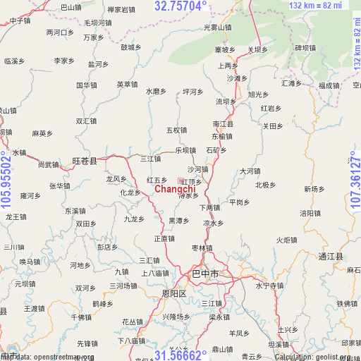
Changchi GPS coordinates[2]
32° 9' 49.572" North, 106° 39' 29.304" East
| Map corner | latitude | longitude |
|---|---|---|
| Upper-left | 32.75704°, | 105.95502° |
| Center: | 32.16377°, | 106.65814° |
| Lower-right: | 31.56662°, | 107.36127° |
| Map W x H: | 132.4×132.4 km | = 82.3×82.3mi |
| max Lat: | 53.31946° ⇑37.8% North |
| Changchi: | 32.16377° |
| min Lat: | ⇓62.2% South 18.22056° |
| min Long | Changchi | max Long |
| 75.07348° | 106.65814° | 134.28917° |
| W 15.3%⇐ | ⇒84.7% E |
Elevation
Elevation of Changchi is 732 m = 2402 ft, and this is 247.2 m = 811 ft above average elevation for this country.
| Max E: |
5622 m = 18445 ft | 19.2% |
| Changchi | 732 m 2402 ft | |
| Avg. | 484.8 m = 1591 ft | |
Min E: |
-3 m = -10 ft | 80.8% |
See also: China elevation on elevation.city.
Geographical zone
Changchi is located in North temperate zone (between Tropic of Cancer and the Arctic Circle). Distance of this Northern Tropic circle is 970.4 km =603 mi to South.| Distance of | km | miles | from Changchi |
|---|---|---|---|
| North Pole | 6430.8 | 3995.9 | to North |
| Arctic Circle | 3824.9 | 2376.7 | to North |
| Tropic Cancer | 970.4 | 603 | to South |
| Equator | 3576.3 | 2222.2 | to South |


Nearby cities:
15 places around Changchi: (largest is in red/bold)
• Chixi
10 km =6.2 mi,  95°
95°
• Fujia
6 km =3.7 mi,  149°
149°
• Gaoqiao
18.6 km =11.6 mi,  115°
115°
• Heitan
14.5 km =9 mi,  182°
182°
• Heping
16.2 km =10.1 mi,  216°
216°
• Hualong
18.8 km =11.7 mi,  258°
258°
• Jinxi
13.7 km =8.5 mi,  359°
359°
• Leba
11.5 km =7.1 mi,  9°
9°
• Mumen
13.8 km =8.6 mi,  244°
244°
• Puji
20.9 km =13 mi,  293°
293°
• Sanjiang
13.7 km =8.5 mi,  306°
306°
• Shahe
7.7 km =4.8 mi,  55°
55°
• Tuanjie
15.9 km =9.9 mi,  29°
29°
• Wuquan
18.8 km =11.7 mi, 355°
• Xialiang
14.4 km =8.9 mi,  132°
132°
Sources, notices
• [Note1] Compared only with cities in China existing in our database
• [Src1] Map data: © OpenStreetMap contributors (CC-BY-SA)
• [Src2] Other city data from geonames.org with taken over terms of usage.
• [Src3] Geographical zone / Annual Mean Temperature by Robert A. Rohde @ Wikipedia
