Baitugang geodata
Baitugang (Henan) is a seat of a fourth-order administrative division; located in China in Asia/Shanghai (GMT+8) time zone. In our database, there are 1268 cities with bigger population. Compared to other cities in China, 67.9% of cities are located further ↓South; 60.8% of cities are located further →East and 54.2% of cities have lower elevation than Baitugang. Note1


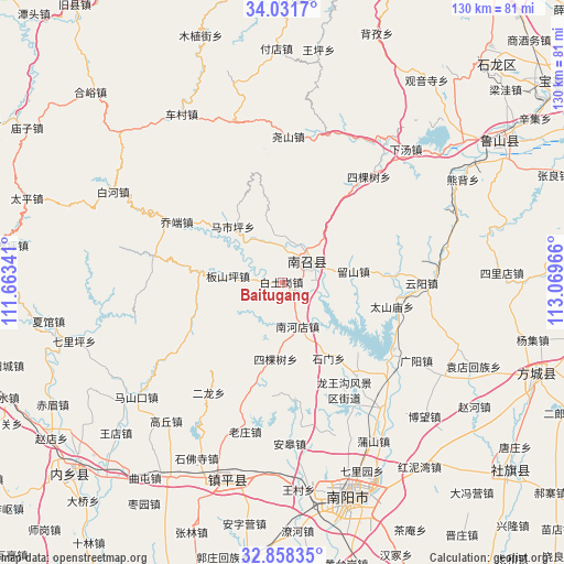
Baitugang GPS coordinates[2]
33° 26' 49.236" North, 112° 21' 59.508" East
| Map corner | latitude | longitude |
|---|---|---|
| Upper-left | 34.0317°, | 111.66341° |
| Center: | 33.44701°, | 112.36653° |
| Lower-right: | 32.85835°, | 113.06966° |
| Map W x H: | 130.5×130.5 km | = 81.1×81.1mi |
| max Lat: | 53.31946° ⇑32.1% North |
| Baitugang: | 33.44701° |
| min Lat: | ⇓67.9% South 18.22056° |
| min Long | Baitugang | max Long |
| 75.07348° | 112.36653° | 134.28917° |
| W 39.2%⇐ | ⇒60.8% E |
Elevation
Elevation of Baitugang is 199 m = 653 ft, and this is 285.8 m = 938 ft below average elevation for this country.
| Max E: |
5622 m = 18445 ft | 45.8% |
| Avg. | 484.8 m = 1591 ft | |
| Baitugang | 199 m = 653 ft | |
Min E: |
-3 m = -10 ft | 54.2% |
See also: China elevation on elevation.city.
Geographical zone
Baitugang is located in North temperate zone (between Tropic of Cancer and the Arctic Circle). Distance of this Northern Tropic circle is 1113 km =691.6 mi to South.| Distance of | km | miles | from Baitugang |
|---|---|---|---|
| North Pole | 6288.1 | 3907.2 | to North |
| Arctic Circle | 3682.2 | 2288 | to North |
| Tropic Cancer | 1113 | 691.6 | to South |
| Equator | 3719 | 2310.9 | to South |


Nearby cities:
15 places around Baitugang: (largest is in red/bold)
• Chengjiao
8.2 km =5.1 mi,  56°
56°
• Cuizhuang
9.6 km =6 mi,  15°
15°
• Erlong
30.4 km =18.9 mi,  213°
213°
• Huangludian
32.8 km =20.4 mi,  130°
130°
• Laozhuang
35.5 km =22.1 mi,  193°
193°
• Liushan
16.9 km =10.5 mi,  79°
79°
• Longxing
28 km =17.4 mi,  172°
172°
• Nanzhao Chengguanzhen
7.6 km =4.7 mi,  48°
48°
• Shimen
20.7 km =12.9 mi,  148°
148°
• Sikeshu
18 km =11.2 mi, 185°
• Sikeshu
31.7 km =19.7 mi,  39°
39°
• Taishanmiao
26.3 km =16.3 mi,  102°
102°
• Xiezhuang
33.7 km =20.9 mi, 169°
• Yaoshan
34 km =21.1 mi,  2°
2°
• Yunyang
32.3 km =20.1 mi,  89°
89°
Sources, notices
• [Note1] Compared only with cities in China existing in our database
• [Src1] Map data: © OpenStreetMap contributors (CC-BY-SA)
• [Src2] Other city data from geonames.org with taken over terms of usage.
• [Src3] Geographical zone / Annual Mean Temperature by Robert A. Rohde @ Wikipedia
