Sikeshu geodata
Sikeshu (Henan) is a seat of a fourth-order administrative division; located in China in Asia/Shanghai (GMT+8) time zone. In our database, there are 1268 cities with bigger population. Compared to other cities in China, 68.6% of cities are located further ↓South; 59.6% of cities are located further →East and 57.2% of cities have lower elevation than Sikeshu. Note1


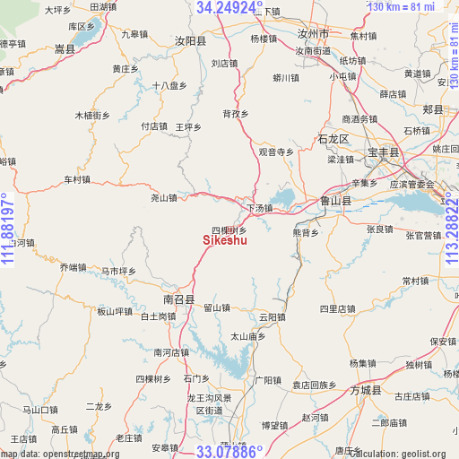
Sikeshu GPS coordinates[2]
33° 39' 57.744" North, 112° 35' 6.324" East
| Map corner | latitude | longitude |
|---|---|---|
| Upper-left | 34.24924°, | 111.88197° |
| Center: | 33.66604°, | 112.58509° |
| Lower-right: | 33.07886°, | 113.28822° |
| Map W x H: | 130.1×130.1 km | = 80.8×80.8mi |
| max Lat: | 53.31946° ⇑31.4% North |
| Sikeshu: | 33.66604° |
| min Lat: | ⇓68.6% South 18.22056° |
| min Long | Sikeshu | max Long |
| 75.07348° | 112.58509° | 134.28917° |
| W 40.4%⇐ | ⇒59.6% E |
Elevation
Elevation of Sikeshu is 227 m = 745 ft, and this is 257.8 m = 846 ft below average elevation for this country.
| Max E: |
5622 m = 18445 ft | 42.8% |
| Avg. | 484.8 m = 1591 ft | |
| Sikeshu | 227 m = 745 ft | |
Min E: |
-3 m = -10 ft | 57.2% |
See also: China elevation on elevation.city.
Geographical zone
Sikeshu is located in North temperate zone (between Tropic of Cancer and the Arctic Circle). Distance of this Northern Tropic circle is 1137.4 km =706.7 mi to South.| Distance of | km | miles | from Sikeshu |
|---|---|---|---|
| North Pole | 6263.7 | 3892.1 | to North |
| Arctic Circle | 3657.9 | 2272.9 | to North |
| Tropic Cancer | 1137.4 | 706.7 | to South |
| Equator | 3743.3 | 2326 | to South |


Nearby cities:
15 places around Sikeshu: (largest is in red/bold)
• Chengjiao
23.9 km =14.9 mi,  214°
214°
• Cuizhuang
23.3 km =14.5 mi,  229°
229°
• Dongzhou
24.4 km =15.2 mi,  57°
57°
• Guanyinsi
26 km =16.2 mi,  30°
30°
• Huanghou
26.1 km =16.2 mi,  142°
142°
• Jizhong
9.3 km =5.8 mi,  110°
110°
• Liushan
21.7 km =13.5 mi,  189°
189°
• Nanzhao Chengguanzhen
24.2 km =15 mi,  217°
217°
• Ranghe
24.8 km =15.4 mi,  83°
83°
• Wawu
25.8 km =16 mi,  15°
15°
• Xiatang
10.6 km =6.6 mi, 55°
• Xiongbei
21 km =13 mi,  91°
91°
• Yaoshan
21 km =13 mi,  297°
297°
• Yunyang
27.1 km =16.8 mi,  153°
153°
• Zhaocun
13.9 km =8.6 mi,  315°
315°
Sources, notices
• [Note1] Compared only with cities in China existing in our database
• [Src1] Map data: © OpenStreetMap contributors (CC-BY-SA)
• [Src2] Other city data from geonames.org with taken over terms of usage.
• [Src3] Geographical zone / Annual Mean Temperature by Robert A. Rohde @ Wikipedia
