Wulingyuan geodata
Wulingyuan (Hunan) is a seat of a third-order administrative division; located in China in Asia/Shanghai (GMT+8) time zone. With population of 52,712 people, there are 797 cities with bigger population in this country. Compared to other cities in China, 61.3% of cities are located further ↑North; 68.9% of cities are located further →East and 65.1% of cities have lower elevation than Wulingyuan. Note1


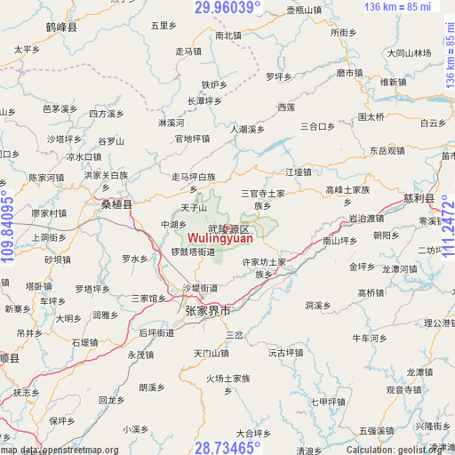
Wulingyuan GPS coordinates[2]
29° 20' 57.696" North, 110° 32' 38.652" East
| Map corner | latitude | longitude |
|---|---|---|
| Upper-left | 29.96039°, | 109.84095° |
| Center: | 29.34936°, | 110.54407° |
| Lower-right: | 28.73465°, | 111.2472° |
| Map W x H: | 136.3×136.3 km | = 84.7×84.7mi |
| max Lat: | 53.31946° ⇑61.3% North |
| Wulingyuan: | 29.34936° |
| min Lat: | ⇓38.7% South 18.22056° |
| min Long | Wulingyuan | max Long |
| 75.07348° | 110.54407° | 134.28917° |
| W 31.1%⇐ | ⇒68.9% E |
Elevation
Elevation of Wulingyuan is 327 m = 1073 ft, and this is 157.8 m = 518 ft below average elevation for this country.
| Max E: |
5622 m = 18445 ft | 34.9% |
| Avg. | 484.8 m = 1591 ft | |
| Wulingyuan | 327 m = 1073 ft | |
Min E: |
-3 m = -10 ft | 65.1% |
See also: Wulingyuan elevation on elevation.city.
Geographical zone
Wulingyuan is located in North temperate zone (between Tropic of Cancer and the Arctic Circle). Distance of this Northern Tropic circle is 657.4 km =408.5 mi to South.| Distance of | km | miles | from Wulingyuan |
|---|---|---|---|
| North Pole | 6743.7 | 4190.3 | to North |
| Arctic Circle | 4137.8 | 2571.1 | to North |
| Tropic Cancer | 657.4 | 408.5 | to South |
| Equator | 3263.3 | 2027.7 | to South |


Nearby cities:
15 places around Wulingyuan: (largest is in red/bold)
• Hezuoqiao
14.9 km =9.3 mi,  168°
168°
• Huochiyu
14.4 km =8.9 mi,  330°
330°
• Liulang
7.1 km =4.4 mi,  208°
208°
• Sanguansi
13.9 km =8.6 mi,  49°
49°
• Shadi
19.4 km =12.1 mi,  203°
203°
• Tianzishan
12.4 km =7.7 mi,  302°
302°
• Xianchiyu
14.6 km =9.1 mi, 331°
• Xinqiao
18.2 km =11.3 mi,  191°
191°
• Xujiafang
15.9 km =9.9 mi,  137°
137°
• Yanghe
18.1 km =11.2 mi,  121°
121°
• Yujiazui
1.9 km =1.2 mi,  76°
76°
• Zhaojiagang
20.8 km =12.9 mi,  38°
38°
• Zhonghuping
15.7 km =9.8 mi,  275°
275°
• Zhuyeping
13.7 km =8.5 mi,  359°
359°
• Zoumaping
16.9 km =10.5 mi,  323°
323°
Sources, notices
• [Note1] Compared only with cities in China existing in our database
• [Src1] Map data: © OpenStreetMap contributors (CC-BY-SA)
• [Src2] Other city data from geonames.org with taken over terms of usage.
• [Src3] Geographical zone / Annual Mean Temperature by Robert A. Rohde @ Wikipedia
