Nanyan geodata
Nanyan (Jiangxi) is a seat of a fourth-order administrative division; located in China in Asia/Shanghai (GMT+8) time zone. In our database, there are 1268 cities with bigger population. Compared to other cities in China, 70.6% of cities are located further ↑North; 68.5% of cities are located further ←West and 73% of cities have higher elevation than Nanyan. Note1


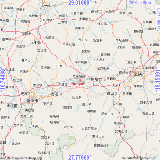
Nanyan GPS coordinates[2]
28° 23' 57.804" North, 117° 26' 52.008" East
| Map corner | latitude | longitude |
|---|---|---|
| Upper-left | 29.01608°, | 116.74466° |
| Center: | 28.39939°, | 117.44778° |
| Lower-right: | 27.77909°, | 118.15091° |
| Map W x H: | 137.5×137.5 km | = 85.4×85.4mi |
| max Lat: | 53.31946° ⇑70.6% North |
| Nanyan: | 28.39939° |
| min Lat: | ⇓29.4% South 18.22056° |
| min Long | Nanyan | max Long |
| 75.07348° | 117.44778° | 134.28917° |
| W 68.5%⇐ | ⇒31.5% E |
Elevation
Elevation of Nanyan is 42 m = 138 ft, and this is 442.8 m = 1453 ft below average elevation for this country.
| Max E: |
5622 m = 18445 ft | 73% |
| Avg. | 484.8 m = 1591 ft | |
| Nanyan | 42 m = 138 ft | |
Min E: |
-3 m = -10 ft | 27% |
See also: China elevation on elevation.city.
Geographical zone
Nanyan is located in North temperate zone (between Tropic of Cancer and the Arctic Circle). Distance of this Northern Tropic circle is 551.8 km =342.9 mi to South.| Distance of | km | miles | from Nanyan |
|---|---|---|---|
| North Pole | 6849.3 | 4256 | to North |
| Arctic Circle | 4243.5 | 2636.8 | to North |
| Tropic Cancer | 551.8 | 342.9 | to South |
| Equator | 3157.7 | 1962.1 | to South |


Nearby cities:
15 places around Nanyan: (largest is in red/bold)
• Gexi
7.3 km =4.5 mi,  8°
8°
• Guifeng
10.9 km =6.8 mi,  221°
221°
• Hetan
15.2 km =9.4 mi,  256°
256°
• Huating
3.9 km =2.4 mi,  351°
351°
• Lianhe
13.4 km =8.3 mi,  97°
97°
• Lingyang
15.9 km =9.9 mi,  80°
80°
• Qingban
15.5 km =9.6 mi,  32°
32°
• Qingban
17.2 km =10.7 mi,  44°
44°
• Qinghu
11.2 km =7 mi,  237°
237°
• Wang’er
14 km =8.7 mi,  151°
151°
• Wanli
9.5 km =5.9 mi,  309°
309°
• Xuguang
14.8 km =9.2 mi,  188°
188°
• Yiyang
1.7 km =1.1 mi,  292°
292°
• Zhongfan
17.1 km =10.6 mi,  336°
336°
• Zhukeng
6.4 km =4 mi, 96°
Sources, notices
• [Note1] Compared only with cities in China existing in our database
• [Src1] Map data: © OpenStreetMap contributors (CC-BY-SA)
• [Src2] Other city data from geonames.org with taken over terms of usage.
• [Src3] Geographical zone / Annual Mean Temperature by Robert A. Rohde @ Wikipedia
