Wang’er geodata
Wang’er (Jiangxi) is a seat of a fourth-order administrative division; located in China in Asia/Shanghai (GMT+8) time zone. In our database, there are 1268 cities with bigger population. Compared to other cities in China, 71.6% of cities are located further ↑North; 68.8% of cities are located further ←West and 68% of cities have higher elevation than Wang’er. Note1


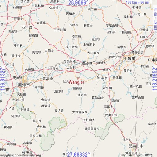
Wang’er GPS coordinates[2]
28° 17' 21.336" North, 117° 30' 59.004" East
| Map corner | latitude | longitude |
|---|---|---|
| Upper-left | 28.9066°, | 116.81327° |
| Center: | 28.28926°, | 117.51639° |
| Lower-right: | 27.66832°, | 118.21952° |
| Map W x H: | 137.7×137.7 km | = 85.6×85.6mi |
| max Lat: | 53.31946° ⇑71.6% North |
| Wang’er: | 28.28926° |
| min Lat: | ⇓28.4% South 18.22056° |
| min Long | Wang’er | max Long |
| 75.07348° | 117.51639° | 134.28917° |
| W 68.8%⇐ | ⇒31.2% E |
Elevation
Elevation of Wang’er is 60 m = 197 ft, and this is 424.8 m = 1394 ft below average elevation for this country.
| Max E: |
5622 m = 18445 ft | 68% |
| Avg. | 484.8 m = 1591 ft | |
| Wang’er | 60 m = 197 ft | |
Min E: |
-3 m = -10 ft | 32% |
See also: China elevation on elevation.city.
Geographical zone
Wang’er is located in North temperate zone (between Tropic of Cancer and the Arctic Circle). Distance of this Northern Tropic circle is 539.6 km =335.3 mi to South.| Distance of | km | miles | from Wang’er |
|---|---|---|---|
| North Pole | 6861.6 | 4263.6 | to North |
| Arctic Circle | 4255.7 | 2644.4 | to North |
| Tropic Cancer | 539.6 | 335.3 | to South |
| Equator | 3145.5 | 1954.5 | to South |


Nearby cities:
15 places around Wang’er: (largest is in red/bold)
• Dieshan
8.4 km =5.2 mi,  185°
185°
• Guifeng
14.5 km =9 mi,  286°
286°
• Hongqiao
17.1 km =10.6 mi,  105°
105°
• Huating
17.6 km =10.9 mi,  335°
335°
• Hufang
14.5 km =9 mi,  166°
166°
• Lianhe
12.3 km =7.6 mi,  32°
32°
• Lianhe
15.8 km =9.8 mi,  45°
45°
• Lingyang
17.4 km =10.8 mi, 31°
• Nanyan
14 km =8.7 mi,  331°
331°
• Qinghu
17.3 km =10.7 mi, 291°
• Xintan
16.7 km =10.4 mi,  72°
72°
• Xin’anbu
8 km =5 mi, 107°
• Xuguang
9.3 km =5.8 mi,  255°
255°
• Yiyang
15.3 km =9.5 mi, 327°
• Zhukeng
11.5 km =7.1 mi,  358°
358°
Sources, notices
• [Note1] Compared only with cities in China existing in our database
• [Src1] Map data: © OpenStreetMap contributors (CC-BY-SA)
• [Src2] Other city data from geonames.org with taken over terms of usage.
• [Src3] Geographical zone / Annual Mean Temperature by Robert A. Rohde @ Wikipedia
