Sanxianling geodata
Sanxianling (Jiangxi) is a seat of a fourth-order administrative division; located in China in Asia/Shanghai (GMT+8) time zone. In our database, there are 1268 cities with bigger population. Compared to other cities in China, 68.3% of cities are located further ↑North; 67.9% of cities are located further ←West and 58.8% of cities have higher elevation than Sanxianling. Note1


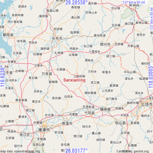
Sanxianling GPS coordinates[2]
28° 40' 13.764" North, 117° 19' 36.912" East
| Map corner | latitude | longitude |
|---|---|---|
| Upper-left | 29.28558°, | 116.6238° |
| Center: | 28.67049°, | 117.32692° |
| Lower-right: | 28.05177°, | 118.03005° |
| Map W x H: | 137.2×137.2 km | = 85.3×85.3mi |
| max Lat: | 53.31946° ⇑68.3% North |
| Sanxianling: | 28.67049° |
| min Lat: | ⇓31.7% South 18.22056° |
| min Long | Sanxianling | max Long |
| 75.07348° | 117.32692° | 134.28917° |
| W 67.9%⇐ | ⇒32.1% E |
Elevation
Elevation of Sanxianling is 106 m = 348 ft, and this is 378.8 m = 1243 ft below average elevation for this country.
| Max E: |
5622 m = 18445 ft | 58.8% |
| Avg. | 484.8 m = 1591 ft | |
| Sanxianling | 106 m = 348 ft | |
Min E: |
-3 m = -10 ft | 41.2% |
See also: China elevation on elevation.city.
Geographical zone
Sanxianling is located in North temperate zone (between Tropic of Cancer and the Arctic Circle). Distance of this Northern Tropic circle is 581.9 km =361.6 mi to South.| Distance of | km | miles | from Sanxianling |
|---|---|---|---|
| North Pole | 6819.2 | 4237.3 | to North |
| Arctic Circle | 4213.3 | 2618 | to North |
| Tropic Cancer | 581.9 | 361.6 | to South |
| Equator | 3187.9 | 1980.9 | to South |


Nearby cities:
15 places around Sanxianling: (largest is in red/bold)
• Baitian
19.2 km =11.9 mi,  201°
201°
• Caoxi
3.9 km =2.4 mi,  25°
25°
• Chenying
25.4 km =15.8 mi,  275°
275°
• Dayuan
16.4 km =10.2 mi,  297°
297°
• Lieqiao
22.5 km =14 mi,  121°
121°
• Lusi
25.5 km =15.8 mi,  354°
354°
• Peimei
22.1 km =13.7 mi,  261°
261°
• Wancun
14.9 km =9.3 mi,  71°
71°
• Wanli
24.5 km =15.2 mi,  169°
169°
• Zhangcun
24.9 km =15.5 mi, 66°
• Zhongbu
19.8 km =12.3 mi, 351°
• Zhongfan
15.3 km =9.5 mi,  160°
160°
• Zhoufang
22.2 km =13.8 mi,  224°
224°
• Zhushan
25.8 km =16 mi, 278°
• Zhutian
25.9 km =16.1 mi,  292°
292°
Sources, notices
• [Note1] Compared only with cities in China existing in our database
• [Src1] Map data: © OpenStreetMap contributors (CC-BY-SA)
• [Src2] Other city data from geonames.org with taken over terms of usage.
• [Src3] Geographical zone / Annual Mean Temperature by Robert A. Rohde @ Wikipedia
