Taohua geodata
Taohua (Jiangxi) is a seat of a fourth-order administrative division; located in China in Asia/Shanghai (GMT+8) time zone. In our database, there are 1268 cities with bigger population. Compared to other cities in China, 68.4% of cities are located further ↑North; 59.3% of cities are located further ←West and 83.9% of cities have higher elevation than Taohua. Note1


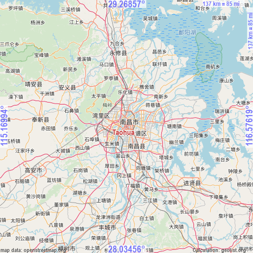
Taohua GPS coordinates[2]
28° 39' 12.168" North, 115° 52' 23.016" East
| Map corner | latitude | longitude |
|---|---|---|
| Upper-left | 29.26857°, | 115.16994° |
| Center: | 28.65338°, | 115.87306° |
| Lower-right: | 28.03456°, | 116.57619° |
| Map W x H: | 137.2×137.2 km | = 85.3×85.3mi |
| max Lat: | 53.31946° ⇑68.4% North |
| Taohua: | 28.65338° |
| min Lat: | ⇓31.6% South 18.22056° |
| min Long | Taohua | max Long |
| 75.07348° | 115.87306° | 134.28917° |
| W 59.3%⇐ | ⇒40.7% E |
Elevation
Elevation of Taohua is 18 m = 59 ft, and this is 466.8 m = 1531 ft below average elevation for this country.
| Max E: |
5622 m = 18445 ft | 83.9% |
| Avg. | 484.8 m = 1591 ft | |
| Taohua | 18 m = 59 ft | |
Min E: |
-3 m = -10 ft | 16.1% |
See also: China elevation on elevation.city.
Geographical zone
Taohua is located in North temperate zone (between Tropic of Cancer and the Arctic Circle). Distance of this Northern Tropic circle is 580 km =360.4 mi to South.| Distance of | km | miles | from Taohua |
|---|---|---|---|
| North Pole | 6821.1 | 4238.4 | to North |
| Arctic Circle | 4215.2 | 2619.2 | to North |
| Tropic Cancer | 580 | 360.4 | to South |
| Equator | 3186 | 1979.7 | to South |


Nearby cities:
15 places around Taohua: (largest is in red/bold)
• Changleng
7.6 km =4.7 mi,  313°
313°
• Dongxin
8.4 km =5.2 mi,  211°
211°
• Fushan
15.5 km =9.6 mi,  187°
187°
• Houtian
22.4 km =13.9 mi,  201°
201°
• Jiangxiangzhen
18.4 km =11.4 mi,  49°
49°
• Jiaoqiao
10.3 km =6.4 mi,  352°
352°
• Lehua
18.7 km =11.6 mi,  357°
357°
• Maqiu
20.1 km =12.5 mi,  84°
84°
• Meiling
19.9 km =12.4 mi,  321°
321°
• Nanchang
3.9 km =2.4 mi,  330°
330°
• Shengmi
11.9 km =7.4 mi,  221°
221°
• Wangcheng
9.2 km =5.7 mi,  283°
283°
• Wuyang
20.1 km =12.5 mi,  138°
138°
• Yangzizhou
8.3 km =5.2 mi,  22°
22°
• Zhaoxian
14.6 km =9.1 mi,  293°
293°
Sources, notices
• [Note1] Compared only with cities in China existing in our database
• [Src1] Map data: © OpenStreetMap contributors (CC-BY-SA)
• [Src2] Other city data from geonames.org with taken over terms of usage.
• [Src3] Geographical zone / Annual Mean Temperature by Robert A. Rohde @ Wikipedia
