Jiangxiangzhen geodata
Jiangxiangzhen (Jiangxi) is a seat of a fourth-order administrative division; located in China in Asia/Shanghai (GMT+8) time zone. In our database, there are 1268 cities with bigger population. Compared to other cities in China, 67.4% of cities are located further ↑North; 60.2% of cities are located further ←West and 82.1% of cities have higher elevation than Jiangxiangzhen. Note1


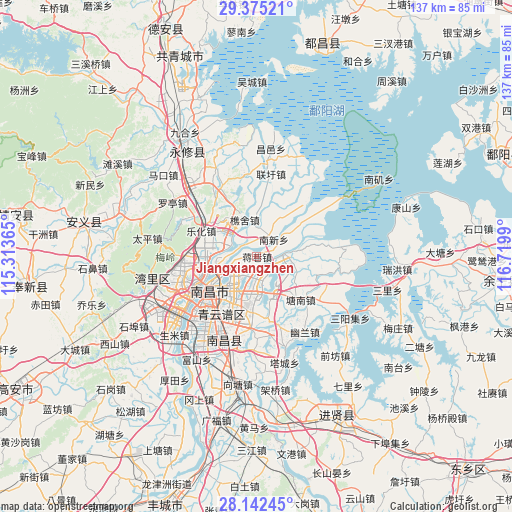
Jiangxiangzhen GPS coordinates[2]
28° 45' 38.34" North, 116° 1' 0.372" East
| Map corner | latitude | longitude |
|---|---|---|
| Upper-left | 29.37521°, | 115.31365° |
| Center: | 28.76065°, | 116.01677° |
| Lower-right: | 28.14245°, | 116.7199° |
| Map W x H: | 137.1×137.1 km | = 85.2×85.2mi |
| max Lat: | 53.31946° ⇑67.4% North |
| Jiangxiangzhen: | 28.76065° |
| min Lat: | ⇓32.6% South 18.22056° |
| min Long | Jiangxiangzhen | max Long |
| 75.07348° | 116.01677° | 134.28917° |
| W 60.2%⇐ | ⇒39.8% E |
Elevation
Elevation of Jiangxiangzhen is 22 m = 72 ft, and this is 462.8 m = 1518 ft below average elevation for this country.
| Max E: |
5622 m = 18445 ft | 82.1% |
| Avg. | 484.8 m = 1591 ft | |
| Jiangxiangzhen | 22 m = 72 ft | |
Min E: |
-3 m = -10 ft | 17.9% |
See also: China elevation on elevation.city.
Geographical zone
Jiangxiangzhen is located in North temperate zone (between Tropic of Cancer and the Arctic Circle). Distance of this Northern Tropic circle is 592 km =367.9 mi to South.| Distance of | km | miles | from Jiangxiangzhen |
|---|---|---|---|
| North Pole | 6809.2 | 4231 | to North |
| Arctic Circle | 4203.3 | 2611.8 | to North |
| Tropic Cancer | 592 | 367.9 | to South |
| Equator | 3197.9 | 1987.1 | to South |


Nearby cities:
15 places around Jiangxiangzhen: (largest is in red/bold)
• Changleng
20.6 km =12.8 mi,  250°
250°
• Jiaoqiao
15.5 km =9.6 mi,  263°
263°
• Jingkou
18.5 km =11.5 mi,  130°
130°
• Lehua
16.3 km =10.1 mi,  294°
294°
• Maqiu
11.6 km =7.2 mi,  148°
148°
• Nanchang
18.1 km =11.2 mi,  241°
241°
• Nanxinxiang
6.4 km =4 mi,  45°
45°
• Qiaoshe
10.5 km =6.5 mi,  341°
341°
• Tangnanzhen
16.3 km =10.1 mi, 134°
• Taohua
18.4 km =11.4 mi,  229°
229°
• Wangcheng
24.9 km =15.5 mi, 247°
• Xiangshan
21.7 km =13.5 mi,  350°
350°
• Xixia
20.1 km =12.5 mi,  302°
302°
• Yangzizhou
11.6 km =7.2 mi, 248°
• Youlan
23.9 km =14.9 mi, 147°
Sources, notices
• [Note1] Compared only with cities in China existing in our database
• [Src1] Map data: © OpenStreetMap contributors (CC-BY-SA)
• [Src2] Other city data from geonames.org with taken over terms of usage.
• [Src3] Geographical zone / Annual Mean Temperature by Robert A. Rohde @ Wikipedia
