Shibi geodata
Shibi (Jiangxi) is a seat of a fourth-order administrative division; located in China in Asia/Shanghai (GMT+8) time zone. In our database, there are 1268 cities with bigger population. Compared to other cities in China, 67.7% of cities are located further ↑North; 57.4% of cities are located further ←West and 69.7% of cities have higher elevation than Shibi. Note1


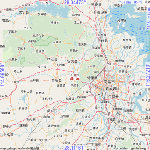
Shibi GPS coordinates[2]
28° 43' 47.964" North, 115° 34' 8.4" East
| Map corner | latitude | longitude |
|---|---|---|
| Upper-left | 29.34473°, | 114.86588° |
| Center: | 28.72999°, | 115.569° |
| Lower-right: | 28.11161°, | 116.27213° |
| Map W x H: | 137.1×137.1 km | = 85.2×85.2mi |
| max Lat: | 53.31946° ⇑67.7% North |
| Shibi: | 28.72999° |
| min Lat: | ⇓32.3% South 18.22056° |
| min Long | Shibi | max Long |
| 75.07348° | 115.569° | 134.28917° |
| W 57.4%⇐ | ⇒42.6% E |
Elevation
Elevation of Shibi is 53 m = 174 ft, and this is 431.8 m = 1417 ft below average elevation for this country.
| Max E: |
5622 m = 18445 ft | 69.7% |
| Avg. | 484.8 m = 1591 ft | |
| Shibi | 53 m = 174 ft | |
Min E: |
-3 m = -10 ft | 30.3% |
See also: China elevation on elevation.city.
Geographical zone
Shibi is located in North temperate zone (between Tropic of Cancer and the Arctic Circle). Distance of this Northern Tropic circle is 588.6 km =365.7 mi to South.| Distance of | km | miles | from Shibi |
|---|---|---|---|
| North Pole | 6812.6 | 4233.2 | to North |
| Arctic Circle | 4206.7 | 2613.9 | to North |
| Tropic Cancer | 588.6 | 365.7 | to South |
| Equator | 3194.5 | 1985 | to South |


Nearby cities:
15 places around Shibi: (largest is in red/bold)
• Changbu
9 km =5.6 mi,  36°
36°
• Changjun
20.7 km =12.9 mi, 43°
• Chi’an
19.9 km =12.4 mi,  257°
257°
• Dinghu
12.2 km =7.6 mi,  348°
348°
• Dongyangzhen
17 km =10.6 mi,  22°
22°
• Fengchuan
18.4 km =11.4 mi, 259°
• Ganzhou
16.5 km =10.3 mi,  306°
306°
• Meiling
18.5 km =11.5 mi,  68°
68°
• Qiaole
9.6 km =6 mi,  183°
183°
• Songbu
7.4 km =4.6 mi,  272°
272°
• Taiping
16.4 km =10.2 mi,  59°
59°
• Wanbu
16.4 km =10.2 mi,  29°
29°
• Wangcheng
21.6 km =13.4 mi,  106°
106°
• Xishan
20.6 km =12.8 mi,  164°
164°
• Zhaoxian
16.5 km =10.3 mi,  99°
99°
Sources, notices
• [Note1] Compared only with cities in China existing in our database
• [Src1] Map data: © OpenStreetMap contributors (CC-BY-SA)
• [Src2] Other city data from geonames.org with taken over terms of usage.
• [Src3] Geographical zone / Annual Mean Temperature by Robert A. Rohde @ Wikipedia
