Taiyangling geodata
Taiyangling (Shaanxi) is a seat of a fourth-order administrative division; located in China in Asia/Shanghai (GMT+8) time zone. In our database, there are 1268 cities with bigger population. Compared to other cities in China, 66.3% of cities are located further ↓South; 86.9% of cities are located further →East and 85.1% of cities have lower elevation than Taiyangling. Note1


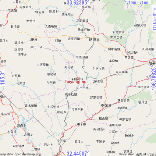
Taiyangling GPS coordinates[2]
33° 2' 11.328" North, 106° 0' 11.232" East
| Map corner | latitude | longitude |
|---|---|---|
| Upper-left | 33.62395°, | 105.3° |
| Center: | 33.03648°, | 106.00312° |
| Lower-right: | 32.44507°, | 106.70625° |
| Map W x H: | 131.1×131.1 km | = 81.5×81.5mi |
| max Lat: | 53.31946° ⇑33.7% North |
| Taiyangling: | 33.03648° |
| min Lat: | ⇓66.3% South 18.22056° |
| min Long | Taiyangling | max Long |
| 75.07348° | 106.00312° | 134.28917° |
| W 13.1%⇐ | ⇒86.9% E |
Elevation
Elevation of Taiyangling is 993 m = 3258 ft, and this is 508.2 m = 1667 ft above average elevation for this country.
| Max E: |
5622 m = 18445 ft | 14.9% |
| Taiyangling | 993 m 3258 ft | |
| Avg. | 484.8 m = 1591 ft | |
Min E: |
-3 m = -10 ft | 85.1% |
See also: China elevation on elevation.city.
Geographical zone
Taiyangling is located in North temperate zone (between Tropic of Cancer and the Arctic Circle). Distance of this Northern Tropic circle is 1067.4 km =663.3 mi to South.| Distance of | km | miles | from Taiyangling |
|---|---|---|---|
| North Pole | 6333.7 | 3935.6 | to North |
| Arctic Circle | 3727.9 | 2316.4 | to North |
| Tropic Cancer | 1067.4 | 663.3 | to South |
| Equator | 3673.3 | 2282.5 | to South |


Nearby cities:
15 places around Taiyangling: (largest is in red/bold)
• Baiquesi
21.8 km =13.5 mi,  18°
18°
• Cangdu
6.7 km =4.2 mi,  336°
336°
• Daijiaba
17.1 km =10.6 mi,  100°
100°
• Donghuanggou
22.3 km =13.9 mi,  70°
70°
• Gongjiahe
19 km =11.8 mi,  63°
63°
• Juting
7.9 km =4.9 mi, 74°
• Kuanchuan
24.3 km =15.1 mi, 101°
• Lesuhe
18.8 km =11.7 mi,  9°
9°
• Lianghe
12.3 km =7.6 mi,  320°
320°
• Tongqian
22.6 km =14 mi,  279°
279°
• Tuohe
13.6 km =8.5 mi,  259°
259°
• Yangba
22.3 km =13.9 mi, 262°
• Yangpingguan
9.5 km =5.9 mi,  150°
150°
• Yanzibian
16.7 km =10.4 mi,  205°
205°
• Zengjiahe
14.8 km =9.2 mi,  50°
50°
Sources, notices
• [Note1] Compared only with cities in China existing in our database
• [Src1] Map data: © OpenStreetMap contributors (CC-BY-SA)
• [Src2] Other city data from geonames.org with taken over terms of usage.
• [Src3] Geographical zone / Annual Mean Temperature by Robert A. Rohde @ Wikipedia
