Tuohe geodata
Tuohe (Gansu) is a seat of a fourth-order administrative division; located in China in Asia/Shanghai (GMT+8) time zone. In our database, there are 1268 cities with bigger population. Compared to other cities in China, 66.2% of cities are located further ↓South; 87.4% of cities are located further →East and 80.6% of cities have lower elevation than Tuohe. Note1


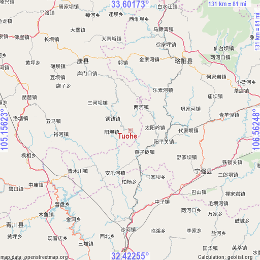
Tuohe GPS coordinates[2]
33° 0' 50.796" North, 105° 51' 33.66" East
| Map corner | latitude | longitude |
|---|---|---|
| Upper-left | 33.60173°, | 105.15623° |
| Center: | 33.01411°, | 105.85935° |
| Lower-right: | 32.42255°, | 106.56248° |
| Map W x H: | 131.1×131.1 km | = 81.5×81.5mi |
| max Lat: | 53.31946° ⇑33.8% North |
| Tuohe: | 33.01411° |
| min Lat: | ⇓66.2% South 18.22056° |
| min Long | Tuohe | max Long |
| 75.07348° | 105.85935° | 134.28917° |
| W 12.6%⇐ | ⇒87.4% E |
Elevation
Elevation of Tuohe is 722 m = 2369 ft, and this is 237.2 m = 778 ft above average elevation for this country.
| Max E: |
5622 m = 18445 ft | 19.4% |
| Tuohe | 722 m 2369 ft | |
| Avg. | 484.8 m = 1591 ft | |
Min E: |
-3 m = -10 ft | 80.6% |
See also: China elevation on elevation.city.
Geographical zone
Tuohe is located in North temperate zone (between Tropic of Cancer and the Arctic Circle). Distance of this Northern Tropic circle is 1064.9 km =661.7 mi to South.| Distance of | km | miles | from Tuohe |
|---|---|---|---|
| North Pole | 6336.2 | 3937.1 | to North |
| Arctic Circle | 3730.3 | 2317.9 | to North |
| Tropic Cancer | 1064.9 | 661.7 | to South |
| Equator | 3670.8 | 2280.9 | to South |


Nearby cities:
15 places around Tuohe: (largest is in red/bold)
• Baiyang
19.1 km =11.9 mi,  337°
337°
• Cangdu
13.8 km =8.6 mi,  51°
51°
• Juting
21.5 km =13.4 mi,  77°
77°
• Lesuhe
26.7 km =16.6 mi,  38°
38°
• Lianghe
13.2 km =8.2 mi,  25°
25°
• Majiaba
27 km =16.8 mi,  151°
151°
• Sanheba
21.7 km =13.5 mi,  310°
310°
• Taiping
16.6 km =10.3 mi,  246°
246°
• Taiyangling
13.6 km =8.5 mi, 79°
• Tongqian
10.8 km =6.7 mi,  304°
304°
• Yangba
8.7 km =5.4 mi,  267°
267°
• Yangpingguan
19 km =11.8 mi,  107°
107°
• Yangtian
26.2 km =16.3 mi,  316°
316°
• Yanzibian
14 km =8.7 mi, 153°
• Zengjiahe
27.6 km =17.1 mi,  64°
64°
Sources, notices
• [Note1] Compared only with cities in China existing in our database
• [Src1] Map data: © OpenStreetMap contributors (CC-BY-SA)
• [Src2] Other city data from geonames.org with taken over terms of usage.
• [Src3] Geographical zone / Annual Mean Temperature by Robert A. Rohde @ Wikipedia
