Dianzi geodata
Dianzi (Gansu) is a seat of a fourth-order administrative division; located in China in Asia/Shanghai (GMT+8) time zone. In our database, there are 1268 cities with bigger population. Compared to other cities in China, 67.1% of cities are located further ↓South; 88.2% of cities are located further →East and 90.3% of cities have lower elevation than Dianzi. Note1


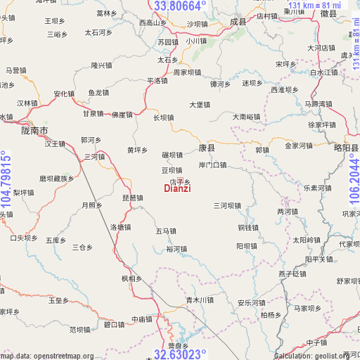
Dianzi GPS coordinates[2]
33° 13' 13.476" North, 105° 30' 4.572" East
| Map corner | latitude | longitude |
|---|---|---|
| Upper-left | 33.80664°, | 104.79815° |
| Center: | 33.22041°, | 105.50127° |
| Lower-right: | 32.63023°, | 106.2044° |
| Map W x H: | 130.8×130.8 km | = 81.3×81.3mi |
| max Lat: | 53.31946° ⇑32.9% North |
| Dianzi: | 33.22041° |
| min Lat: | ⇓67.1% South 18.22056° |
| min Long | Dianzi | max Long |
| 75.07348° | 105.50127° | 134.28917° |
| W 11.8%⇐ | ⇒88.2% E |
Elevation
Elevation of Dianzi is 1384 m = 4541 ft, and this is 899.2 m = 2950 ft above average elevation for this country.
| Max E: |
5622 m = 18445 ft | 9.7% |
| Dianzi | 1384 m 4541 ft | |
| Avg. | 484.8 m = 1591 ft | |
Min E: |
-3 m = -10 ft | 90.3% |
See also: China elevation on elevation.city.
Geographical zone
Dianzi is located in North temperate zone (between Tropic of Cancer and the Arctic Circle). Distance of this Northern Tropic circle is 1087.8 km =675.9 mi to South.| Distance of | km | miles | from Dianzi |
|---|---|---|---|
| North Pole | 6313.3 | 3922.9 | to North |
| Arctic Circle | 3707.4 | 2303.7 | to North |
| Tropic Cancer | 1087.8 | 675.9 | to South |
| Equator | 3693.8 | 2295.2 | to South |


Nearby cities:
15 places around Dianzi: (largest is in red/bold)
• Anmenkou
13.3 km =8.3 mi,  61°
61°
• Changba
23.9 km =14.9 mi,  345°
345°
• Douba
5.1 km =3.2 mi,  322°
322°
• Gongji
25.7 km =16 mi,  5°
5°
• Huangping
19.3 km =12 mi,  305°
305°
• Jia’an
21.1 km =13.1 mi,  77°
77°
• Nianba
10 km =6.2 mi,  342°
342°
• Pipa
18.5 km =11.5 mi,  251°
251°
• Sanguan
17.8 km =11.1 mi,  32°
32°
• Sanheba
19 km =11.8 mi,  117°
117°
• Wuma
18.3 km =11.4 mi,  197°
197°
• Xizhi
20.9 km =13 mi,  220°
220°
• Yangtian
15.7 km =9.8 mi,  104°
104°
• Yuhe
24.7 km =15.3 mi,  183°
183°
• Zuitai
15.6 km =9.7 mi,  38°
38°
Sources, notices
• [Note1] Compared only with cities in China existing in our database
• [Src1] Map data: © OpenStreetMap contributors (CC-BY-SA)
• [Src2] Other city data from geonames.org with taken over terms of usage.
• [Src3] Geographical zone / Annual Mean Temperature by Robert A. Rohde @ Wikipedia
