Wuma geodata
Wuma (Gansu) is a seat of a fourth-order administrative division; located in China in Asia/Shanghai (GMT+8) time zone. In our database, there are 1268 cities with bigger population. Compared to other cities in China, 66.4% of cities are located further ↓South; 88.3% of cities are located further →East and 88.4% of cities have lower elevation than Wuma. Note1


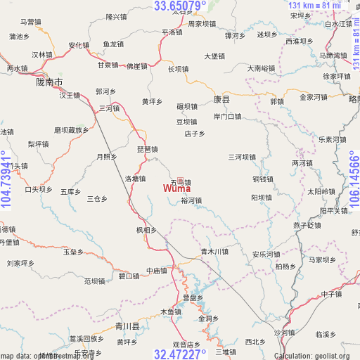
Wuma GPS coordinates[2]
33° 3' 48.6" North, 105° 26' 33.108" East
| Map corner | latitude | longitude |
|---|---|---|
| Upper-left | 33.65079°, | 104.73941° |
| Center: | 33.0635°, | 105.44253° |
| Lower-right: | 32.47227°, | 106.14566° |
| Map W x H: | 131×131 km | = 81.4×81.4mi |
| max Lat: | 53.31946° ⇑33.6% North |
| Wuma: | 33.0635° |
| min Lat: | ⇓66.4% South 18.22056° |
| min Long | Wuma | max Long |
| 75.07348° | 105.44253° | 134.28917° |
| W 11.7%⇐ | ⇒88.3% E |
Elevation
Elevation of Wuma is 1225 m = 4019 ft, and this is 740.2 m = 2428 ft above average elevation for this country.
| Max E: |
5622 m = 18445 ft | 11.6% |
| Wuma | 1225 m 4019 ft | |
| Avg. | 484.8 m = 1591 ft | |
Min E: |
-3 m = -10 ft | 88.4% |
See also: China elevation on elevation.city.
Geographical zone
Wuma is located in North temperate zone (between Tropic of Cancer and the Arctic Circle). Distance of this Northern Tropic circle is 1070.4 km =665.1 mi to South.| Distance of | km | miles | from Wuma |
|---|---|---|---|
| North Pole | 6330.7 | 3933.7 | to North |
| Arctic Circle | 3724.9 | 2314.5 | to North |
| Tropic Cancer | 1070.4 | 665.1 | to South |
| Equator | 3676.3 | 2284.3 | to South |


Nearby cities:
15 places around Wuma: (largest is in red/bold)
• Anmenkou
29.4 km =18.3 mi,  35°
35°
• Dianzi
18.3 km =11.4 mi,  17°
17°
• Douba
21.7 km =13.5 mi,  6°
6°
• Fengxiang
21.7 km =13.5 mi,  214°
214°
• Luotang
16.6 km =10.3 mi,  271°
271°
• Nianba
27.1 km =16.8 mi, 5°
• Pandi
24.7 km =15.3 mi,  257°
257°
• Pipa
16.6 km =10.3 mi,  313°
313°
• Sanheba
24 km =14.9 mi,  68°
68°
• Taiping
26.6 km =16.5 mi,  117°
117°
• Weihe
13.4 km =8.3 mi,  235°
235°
• Xizhi
8.2 km =5.1 mi,  280°
280°
• Yangtian
24.6 km =15.3 mi,  57°
57°
• Yuezhao
27.6 km =17.1 mi,  288°
288°
• Yuhe
8.2 km =5.1 mi,  150°
150°
Sources, notices
• [Note1] Compared only with cities in China existing in our database
• [Src1] Map data: © OpenStreetMap contributors (CC-BY-SA)
• [Src2] Other city data from geonames.org with taken over terms of usage.
• [Src3] Geographical zone / Annual Mean Temperature by Robert A. Rohde @ Wikipedia
