Xizhi geodata
Xizhi (Gansu) is a seat of a fourth-order administrative division; located in China in Asia/Shanghai (GMT+8) time zone. In our database, there are 1268 cities with bigger population. Compared to other cities in China, 66.5% of cities are located further ↓South; 88.5% of cities are located further →East and 91.8% of cities have lower elevation than Xizhi. Note1


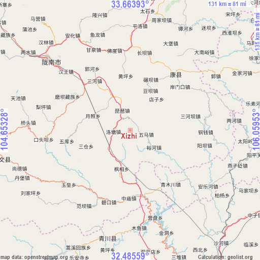
Xizhi GPS coordinates[2]
33° 4' 36.228" North, 105° 21' 23.04" East
| Map corner | latitude | longitude |
|---|---|---|
| Upper-left | 33.66393°, | 104.65328° |
| Center: | 33.07673°, | 105.3564° |
| Lower-right: | 32.48559°, | 106.05953° |
| Map W x H: | 131×131 km | = 81.4×81.4mi |
| max Lat: | 53.31946° ⇑33.5% North |
| Xizhi: | 33.07673° |
| min Lat: | ⇓66.5% South 18.22056° |
| min Long | Xizhi | max Long |
| 75.07348° | 105.3564° | 134.28917° |
| W 11.5%⇐ | ⇒88.5% E |
Elevation
Elevation of Xizhi is 1553 m = 5095 ft, and this is 1068.2 m = 3505 ft above average elevation for this country.
| Max E: |
5622 m = 18445 ft | 8.2% |
| Xizhi | 1553 m 5095 ft | |
| Avg. | 484.8 m = 1591 ft | |
Min E: |
-3 m = -10 ft | 91.8% |
See also: China elevation on elevation.city.
Geographical zone
Xizhi is located in North temperate zone (between Tropic of Cancer and the Arctic Circle). Distance of this Northern Tropic circle is 1071.9 km =666 mi to South.| Distance of | km | miles | from Xizhi |
|---|---|---|---|
| North Pole | 6329.3 | 3932.8 | to North |
| Arctic Circle | 3723.4 | 2313.6 | to North |
| Tropic Cancer | 1071.9 | 666 | to South |
| Equator | 3677.8 | 2285.3 | to South |


Nearby cities:
15 places around Xizhi: (largest is in red/bold)
• Caohe
30.2 km =18.8 mi,  238°
238°
• Dianzi
20.9 km =13 mi,  40°
40°
• Douba
22.6 km =14 mi,  27°
27°
• Fengxiang
19.9 km =12.4 mi,  192°
192°
• Huangping
27.3 km =17 mi,  355°
355°
• Luotang
8.6 km =5.3 mi,  263°
263°
• Nianba
27.6 km =17.1 mi,  22°
22°
• Pandi
17.4 km =10.8 mi,  247°
247°
• Pipa
10.7 km =6.6 mi,  338°
338°
• Sancang
23.6 km =14.7 mi, 252°
• Weihe
9.5 km =5.9 mi,  198°
198°
• Wuma
8.2 km =5.1 mi,  100°
100°
• Yuezhao
19.5 km =12.1 mi,  291°
291°
• Yuhe
14.9 km =9.3 mi,  125°
125°
• Yuhuang
26.9 km =16.7 mi,  332°
332°
Sources, notices
• [Note1] Compared only with cities in China existing in our database
• [Src1] Map data: © OpenStreetMap contributors (CC-BY-SA)
• [Src2] Other city data from geonames.org with taken over terms of usage.
• [Src3] Geographical zone / Annual Mean Temperature by Robert A. Rohde @ Wikipedia
